


National Register Listings by County: Jasper-St. Francois
Hyperlinked text at the beginning of a listing goes to a word-searchable National Register nomination for that resource; other links provide maps or additional information for the resource. These items can be downloaded to your device and opened in a PDF reader.
- Jasper County National Register Listings
66 Drive-In, 17231 Old 66 Blvd., Carthage (4/02/03)
Bank of Avilla, 205 Greenfield St., Avilla (3/7/2022)
Boots Court (Route 66 in Missouri MPDF), 107 S. Garrison Ave., Carthage (9/26/2022)
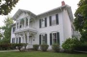
Buchanan, Lucius P., House, 3708 E. University Parkway, Joplin (8/22/16)
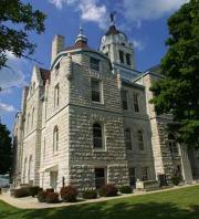
Carthage Courthouse Square Historic District (map), roughly bounded by East Central Avenue, South Maple, Lincoln, and West Fifth streets, Carthage (5/15/80)
Carthage South Historic District (Historic Resources of the City of Carthage MRA; map), roughly bounded by Garrison and Centennial avenues, Fifth and Clinton streets, Carthage (5/06/82)
Cassill Place Historic District (Historic Resources of the City of Carthage MRA), 500 block of West Central, Carthage (1/02/86)
Cave Spring School and Cave Spring Cemetery (One-Teacher Public Schools of Missouri, c. 1774 to c. 1973 MPDF), 4323 County Road 4, Sarcoxie vicinity (7/17/12)
Cleveland Apartments (Historic Resources of Joplin, Missouri MPDF), 801-807 W. First St. and 104 N. Jackson Ave., Joplin (12/23/2021)
Colonial Apartments, 406 Walnut St., Carthage (8/14/01)
Downtown Webb City Historic District, Roughly North and South Main, East and West Broadway, Daugherty, East Church, North Tom, North Liberty, North and South Webb, Webb City (7/18/14)
Elks Club Lodge #501, 318-320 W. Fourth St., Joplin (6/03/85)
Gentry Apartments, 318 S. Wall St., Joplin (8/08/06)
Fifth and Main Historic District (map), 501-513 S. Main St., 502-508 Virginia St., Joplin (7/05/06)
Fox Theater, 415 S. Main St., Joplin (7/30/90)
Inter-State Grocer Co. Building (Historic Resources of Joplin, Missouri MPDF), 1027-1035 S. Main St., Joplin (10/24/08)
Jasper County Courthouse, Courthouse Square, Carthage (2/08/73)
Joplin and Wall Avenues Historic District (Historic Resources of Joplin, Missouri MPDF), portions of South Joplin and Wall avenues, West First, Second, Third streets, Joplin (10/12/10)
Joplin Carnegie Library, Ninth and Wall streets, Joplin (7/10/79)
Joplin Connor Hotel, 324 Main St., Joplin (2/28/73; demolished)
Joplin Downtown Historic District (Historic Resources of Joplin, Missouri MPDF), South Main Street, roughly between East Fourth and East Sixth streets, Joplin (7/16/08)
Joplin East Town Historic District (map), roughly bounded by Broadway-Langston Hughes, Landreth Avenue, Hill Street and Division Avenue, Joplin (11/02/2022)
Joplin Furniture Company Building (Historic Resources of Joplin, Missouri MPDF), 702-708 Main St., Joplin (8/07/12)
Joplin Supply Co., 228 S. Joplin Ave., Joplin (7/03/07)
Joplin Union Depot, Broadway and Main streets, Joplin (3/14/73)
Joplin YMCA (Historic Resources of Joplin, Missouri MPDF), 510 S. Wall Ave., Joplin (01/19/2021)
Main and Eight Streets Historic District (Historic Resources of Joplin, Missouri MPDF), portions of the 800 and 900 blocks of South Main Street, Joplin (4/15/11)
Memorial Hall, 212 W. Eighth St., Joplin (10/7/2021)
Middle West Hotel, 1 S. Main St., Webb City (9/16/82)
Murphysburg Historic District (Historic Resources of Joplin, Missouri MPDF), Roughly bounded by South Sergeant, South Pearl and South Byers avenues, West First, West Fourth and West Seventh streets, Joplin (5/18/15)
Newman Brothers Building, 602-608 S. Main St., Joplin (7/23/90)
Olivia Apartments, 320 Moffet, Joplin (6/20/08)
Pennington Drug Company (Historic Resources of Joplin, Missouri MPDF), 512-520 Virginia Ave., Joplin (10/10/17)
Phelps Country Estate (Historic Resources of the City of Carthage MRA), SR 1, 10th St. Road, approx. 4 miles northeast of of Carthage (8/29/83)
Rains Brothers Building, 906-908 S. Main St., Joplin (7/19/90)
Ridgway Apartments, 402 and 404 S. Byers Ave., Joplin (8/08/06)
St. Louis and San Francisco Railroad Building, 605 Main St., Joplin (10/22/02)
St. Peter the Apostle Catholic Church and Rectory, 812 Pearl St., Joplin (6/28/91)
Sarcoxie Public Square Historic District, along Fifth, Sixth, Center and Cross streets, Sarcoxie (10/20/14)
Scottish Rite Cathedral, 505 Byers Ave., Joplin (6/21/90)
South Main Street Historic District (Historic Resources of Joplin, Missouri MPDF), west side South Main Street, between West First and West Second streets, Joplin (10/12/10)
Webb, Elijah Thomas Residence, 4 S. Liberty St., Webb City (7/20/2020)
- Jefferson County National Register Listings
Beaumont-Tyson Quarry District, address restricted (10/10/74)
Boemler Archaeological District, address restricted (10/01/74)
Boland Archaeological District, address restricted (10/01/74)
Central School Campus, 221 S. Third St., De Soto (10/08/09)
Fletcher, Thomas C., House, Elm Street between First and Second streets, Hillsboro (11/19/74)
Greystone-Meissner, Gustave, House, northeast of Pevely off U.S. 61/67 (12/31/74); additional information (3/11/85)
Kimmswick Bone Bed, northwest of Imperial, Kimmswick vicinity (11/05/80)
Kimmswick Historic District (map), roughly bounded by Front Street, Fourth Street, Mill Street, Elm Street and Oak Street, Kimmswick (7/24/07)
Leight, Valentine, General Store, 4566 Main St., House Springs (8/18/92)
Moder Archaeological District, address restricted (10/16/74)
Rozier, Louis J. and Harriet, House, 322 W. Clement, De Soto (4/05/06)
Sandy Creek Covered Bridge, 5 miles north of Hillsboro off U.S. 21 (7/08/70)
Stonebrook, 3511 Stonebrook Forest, Antonia vicinity (1/14/11)
Waggener Dairy Barn, 1700 Boyce Lane, Festus vicinity (2/24/2022)
Windsor Harbor Road Bridge, Windsor Harbor Road at Rock Creek, Kimmswick (9/08/83)
- Johnson County National Register Listings
Adams, John A., Farmstead Historic District, 431 SE Y Highway, Warrensburg vicinity (7/7/94)
Camp Shawnee Historic District (ECW Architecture in Missouri State Parks, 1933-1942 TR), southwest of Knob Noster off MO 132 (3/04/85)
Chilhowee Historic District (map), roughly Walnut and Main streets, Chilhowee (6/02/88)
Cress, Herbert A. and Bettie E. House, 222 W. Gay St., Warrensburg (10/12/95)
Garden of Eden Station, junction of MO 13 and County Road 215 NW, Warrensburg vicinity (4/08/94)
Griebel, Lewis and Sophie, House (Historic and Architectural Resources of Warrensburg, MO MPDF), 300 W. Gay St., Warrensburg (10/31/12)
Grover Street Victorian Historic District (Historic and Architectural Resources of Warrensburg, MO MPDF), 209, 210, 211, 212, 214, 216 and 218 Grover St., Warrensburg (7/18/12)
Holden and Pine Streets Commercial Historic District, roughly bounded by Maynard, North College, East Gay, West Market, Marshall and Railroad streets, and North Washington Avenue, Warransburg (4/3/17)
Howard School, 400 W. Culton St., Warrensburg (2/14/02)
Johnson County Courthouse, Courthouse Square, Warrensburg (4/07/94)
Johnson County Courthouse, Old, Old Public Square, Warrensburg (6/15/70)
Jones Brothers Mule Barn, 101 N. College Ave, Warrensburg (2/22/11)
Magnolia Mills, 200 W. Pine St., Warrensburg (10/03/96)
Masonic Temple, 101-1-3 W. Market St. and 301-303 N. Holden St., Warrensburg (12/24/98)
Miller, Joseph M., Mausoleum, 0.8 mile north of junction of MO 131 and Second Street, Holden (1/29/18)
Montserrat Recreation Demonstration Area Bridge (ECW Architecture in Missouri State Parks, 1933-1942 TR), southwest of Knob Noster off MO 132 (3/04/85)
Montserrat Recreation Demonstration Area Dam and Spillway (ECW Architecture in Missouri State Parks, 1933-1942 TR), southwest of Knob Noster off MO 132 (3/04/85)
Montserrat Recreation Demonstration Area Entrance Portal (ECW Architecture in Missouri State Parks, 1933-1942 TR), southwest of Knob Noster off MO 132 (3/04/85)
Montserrat Recreation Demonstration Area Rock Bath House (ECW Architecture in Missouri State Parks, 1933-1942 TR), southwest of Knob Noster off MO 132 (3/04/85)
Montserrat Recreation Demonstration Area Warehouse #2 and Workshop (ECW Architecture in Missouri State Parks, 1933-1942 TR), southwest of Knob Noster off MO 132 (3/04/85)
Pleasant View School, 674 SW 131 Highway, Medford vicinity (8/05/99)
Warren Street Methodist Episcopal Church, 201 S. Warren St., Warrensburg (12/13/96)
- Knox County National Register Listings
Edina Double Square Historic District (map), roughly along portions of Main and East Lafayette streets, Edina (7/28/99)
Edina Double Square Historic District (Boundary Increase; map), 118-124 S. Main St., Edina (3/13/02)
- Laclede County National Register Listings
Bennett Spring State Park Hatchery-Lodge Area Historic District (ECW Architecture in Missouri State Parks, 1933-1942 TR), off MO 64 (3/04/85)
Burley, Ralph E., House, 389 S. Adams Ave., Lebanon (7/07/94)
Knight, Joe, Building, 201 W. Commercial St., Lebanon (9/06/05)
Laclede County Jail, Adams and Third streets, Lebanon (listed 3/27/80; demolished 08/2021; delisted 2/4/22)
Missouri Farmers Association-Producers Creamery Co. Dairy Plant, 1201 Ice Cream Way, Lebanon (4/9/2025)
Ploger-Moneymaker Place, 291 Harwood Ave., Lebanon (9/23/82)
Rice-Stix Building, 200 E. Commercial St., Lebanon (7/25/2019)
Wallace House, 230 Harwood Ave., Lebanon (3/22/84)
- Lafayette County National Register Listings
Anderson House and Lexington Battlefield, Lexington (6/04/69)
Buck, Napoleon, House (Antebellum Resources of Johnson, Lafayette, Pettis, and Saline Counties, Missouri MPDF), 0.40 mile south of junction of US 24 and MO 273, Waverly vicinity (11/14/97)
Catron, Minatree, House (Antebellum Resources of Johnson, Lafayette, Pettis, and Saline Counties, Missouri MPDF), 0.1 mile west of junction of US 24 and MO 110, Lexington vicinity (11/14/97)
Cheatham, John E., House (Historic Resources of Lexington MRA), 739 MO 13, Lexington (7/08/93)
Chicago and Alton Railroad Depot at Higginsville, 2109 Main St., Higginsville (3/25/87)
Commercial Community Historic District (Map; Historic Resources of Lexington MRA), roughly bounded by Eighth, 13th, South, Broadway and Main streets, Lexington (8/04/83)
Confederate Chapel, Cemetery and Cottage, Higginsville vicinity (12/16/81)
Cumberland Presbyterian Church (Old Library Building, Historic Museum), 112 S. 13th St., Lexington (11/14/78)
Dinwiddie, James M., House (Antebellum Resources of Johnson, Lafayette, Pettis, and Saline Counties, Missouri MPDF), 0.25 mile east of junction of US 24 and MO 184, Dover vicinity (11/14/97)
Douglass School, 215 W. 16th St., Higginsville (3/10/2023)
Eneberg, John F., House (Historic Resources of Lexington MRA), 157 N. 10th St., Lexington (7/8/93; removed 6/6/03)
Forest Grove Cemetery, 892 Golf Road, Lexington vicinity (7/18/2022)
Gosewisch, Theodore, House (Antebellum Resources of Johnson, Lafayette, Pettis, and Saline Counties, Missouri MPDF), 0.5 mile west of junction of MO 13 and Marshall School Road, Lexington vicinity (11/14/97)
Graves, Alexander and Elizabeth Aull, House (Historic Resources of Lexington MRA), 2326 Aull Lane, Lexington (7/08/93)
Hicklin Hearthstone, east of Lexington on US 24 (12/28/82)
Hicklin School, MO 24, Lexington vicinity (2/24/04)
Highland Avenue Historic District (Historic Resources of Lexington MRA), roughly bounded by Highland Avenue, from Rock Street to Bluff Street, Lexington (8/04/83)
House at 1413 Lafayette Street, Lexington (3/25/99)
Houx-Hoefer-Rehkop House (Leonard Rehkop Residence), 1900 Walnut St., Higginsville (3/29/83)
John, David, House (Historic Resources of Lexington MRA), 103 S. 23rd St., Lexington (7/08/93)
Johnson, George, House (Historic Resources of Lexington MRA), 102 S. 30th St., Lexington (7/08/93)
Lafayette County Courthouse, Public Square, Lexington (9/22/70)
Linwood Lawn, southeast of Lexington off US 24 (4/23/73)
Machpelah Cemetery, 900 S. 20th St., Lexington (6/27/2022)
Odessa Ice Cream Co. Building, 101 W. Dryden St., Odessa (10/03/96)
Old Neighborhoods Historic District (map; Historic Resources of Lexington MRA), roughly bounded by 13th, 22nd and South streets and Forest and Washington avenues, Lexington (8/04/83)
Robinson, William P., House (Antebellum Resources of Johnson, Lafayette, Pettis, and Saline Counties, Missouri MPDF), 0.2 mile east and 0.15 mile south of junction of MO 107 and MO 112, Lexington vicinity (11/14/97)
Shelby, Thomas, House (Antebellum Resources of Johnson, Lafayette, Pettis, and Saline Counties, Missouri MPDF), 0.25 mile east of US 24 and MO 111, Lexington vicinity (11/14/97)
Spratt-Allen-Aull House (Historic Resources of Lexington MRA), 2321 Aull Lane, Lexington (7/08/93)
Stramcke, Thomas Talbot and Rebecca Walton Smithers, House, 15834 Highway O, Lexington vicinity (9/29/99)
Tevis, D.W.B. and Julia Waddell, House (Historic Resources of Lexington MRA), 505 S. 13th St., Lexington (7/08/93)
Waddell House, 1704 South St., Lexington (10/11/79)
Wentworth Military Academy, Washington Avenue and 18th Street, Lexington (11/24/80)
- Lawrence County National Register Listings
Lawrence County Courthouse Coleman, Lewis Shaw, House, 227 E. College St., Aurora (10/17/16)
Lawrence County Bank Building, 100 W. Commercial St., Pierce City (3/10/05)
Lawrence County Courthouse, City Square, Mount Vernon (9/23/80)
Old Spanish Fort Archaeological Site, address restricted (1/25/71)
Pierce City Fire Station, Courthouse and Jail, Walnut Street, Pierce City (8/28/98)
- Lewis County National Register Listings
First Presbyterian Church (Rural Church Architecture of Missouri, c. 1819 to c. 1945 MPDF), 401 Jefferson, La Grange (8/28/12)
Gray, William, House (Historic Resources of La Grange, Missouri MPDF), 407 Washington, La Grange (6/03/99)
Hay, Dr. J. A., House (Historic Resources of La Grange, Missouri MPDF), 406 W. Monroe St., La Grange (6/03/99)
Henderson Hall, College Hill, Canton (10/02/78)
Hipkins, Joseph, House (Historic Resources of La Grange, Missouri MPDF), 500 S. Third St., La Grange (5/08/08)
Lewis County Courthouse, 100 E. Lafayette St., Monticello (1/12/05)
Lincoln School, MO Highway B, Canton (2/10/83)
Lock and Dam No. 20 Historic District (Upper Mississippi River 9-Foot Navigation Project MPDF), 0.5 mile north of Henderson Street, Canton (3/10/04)
McKoon, John, House (Historic Resources of La Grange, Missouri MPDF), 500 W. Monroe St., La Grange (6/03/99)
Quincy, Missouri, and Pacific Railroad Station, off MO 16, Lewistown (5/07/79)
Rhoda, Fred, House (Historic Resources of La Grange, Missouri MPDF), 200 S. Second St., La Grange (6/03/99)
Waltman, A. C., House (Historic Resources of La Grange, Missouri MPDF), 302 Lewis St., La Grange (6/03/99)
- Lincoln County National Register Listings
Camp Sherwood Forest Historic District (ECW Architecture in Missouri State Parks, 1933-1942 TR), southwest of Elsberry (3/04/85)
Cuivre River State Park Administrative Area Historic District (ECW Architecture in Missouri State Parks, 1933-1942 TR), southwest of Elsberry (3/04/85)
Downtown Troy Historic District, bounded by Annie Avenue and Second, Marble and Court streets, Troy (10/30/13)
Lock and Dam No. 25 Historic District (Upper Mississippi River 9-Foot Navigation Project MPDF), 10 Sandy Slough Road, Winfield (3/10/04)
Old Rock House (Shapley Ross House), Second and Mill streets, Moscow Mills (10/18/72)
- Linn County National Register Listings

Gen John J. Pershing Home Christian Church, 116 W. Gracia Ave., Marceline (3/29/2025)
Lincoln School, 210 West Wells, Marceline (3/20/2025)
Linn County Courthouse, 108 High St., Linneus (10/14/99)
Linn County Jail and Sheriff's Residence, 102 N. Main St., Linneus (1/16/01)
Locust Creek Covered Bridge, originally located 3 miles west of Laclede off U.S. 36; now located along Ellen Road in Pershing State Park, Laclede vicinity (5/19/70)
Marceline Masonic Lodge #481, 201 N. Main St. USA, Marceline (3/20/2025)
Marceline Mercantile & Supply Co., 125 E. California, Marceline (3/19/2025)
Pershing, Gen. John J., Boyhood Home, State and Worlow streets, Laclede (5/21/69; NHL 5/11/76)
Plum Grove School, County Road 350, 3/8 mile north of junction with County Road 346, Laclede vicinity (10/22/94)
Uptown Theatre, 104 N. Main St. USA, Marceline (7/3/2023)
- Livingston County National Register Listings

Grace Episcopal Church Chillicothe Commercial Historic District (Historic and Architectural Resources of Chillicothe, Missouri MPDF; map), roughly bounded Clay, Ann, Washington and Locust streets, Chillicothe (10/16/02)
Chillicothe Industrial Home for Girls, 1500 Third St., Chillicothe (4/19/10)
Courthouse Square Historic District (Historic and Architectural Resources of Chillicothe, Missouri MPDF; map), roughly bounded by Calhoun, Jackson, Washington and Elm streets, Chillicothe (10/16/02)
Grace Episcopal Church and Building, 421 Elm St., Chillicothe (9/17/80)
- Macon County National Register Listings
Macon County Courthouse Blees Military Academy, U.S. 63 South, Macon (10/11/79)
Dent, Lester and Norma, House, 225 N. Church St., La Plata (5/18/90)
Doneghy, John T. and Mary M., House, 301 N. Owensby St., La Plata (3/22/90)
Gardner and Tinsely Filling Station, Old U.S. 36, near junction with MO 149 (4/25/02)
Gilbreath-McLorn House, 225 N. Owenby, La Plata (11/16/78)
La Plata Square Historic District, along portions of Gex, Sanders and Moore streets, La Plata (11/20/08)
Macon County Courthouse and Annex, Courthouse Square, Macon (12/08/78)
Morrow, Johnson, House, Second Street west of junction with Pine Street, Callao (7/07/94)
Wardell House, 1 Wardell Road, Macon (3/12/86)
- Madison County National Register Listings
Fredericktown Courthouse Square Historic District, 110-145 E. Main St., 106-125 W. Main St., 110-120 S. Main St. and Court Square, Fredericktown (7/08/09)
Fredericktown Missouri Pacific Railroad Depot, 406 Villar St., Fredericktown (2/10/00)
Fredericktown United States Post Office, 155 S. Main St., Fredericktown (10/08/09)
Madison County Courthouse, 1 Courthouse Square, Fredericktown (12/28/00)
St. Louis, Iron Mountain and Southern Railroad Depot, Allen Street 150 feet north of junction of Allen and Kelly streets, Fredericktown (10/19/05)
- Maries County National Register Listings
Maries County Jail and Sheriff's Residence, Fifth and Mill streets, Vienna (3/1/02)
- Marion County National Register Listings
Barkley, Levi, House, Hannibal vicinity (3/02/84)
Broadway District (Hannibal Central Business District MRA; map), roughly bounded by South Main, Broadway and South Third streets, Hannibal (8/01/86)
Buildings at 207-209 S. Main Street (Hannibal Central Business District MRA; map), 207-209 S. Main St., Hannibal (8/01/86)
Central Park Historic District, roughly bounded by Fourth, Seventh, North and Lyon streets, Hannibal (10/07/82)
Clemens Field, 401 Collier, Hannibal (8/26/08)
Culbertson-Head Farmstead, 7178 County Road 402, Palmyra (9/04/08)
Davidson Building (Hannibal Central Business District MRA; map), 106 S. Main St., Hannibal (8/01/86)
Digel Block (Hannibal Central Business District MRA; map), 218-222 S. Main St., Hannibal (8/01/86)
Dryden-Louthan House, 402 E. Ross, Palmyra (1/18/85)
Ebert-Dulany House, 1000 Center St., Hannibal (2/17/83)
Eighth and Center Streets Baptist Church, 722 Center St., Hannibal (9/04/80)
Elliott's, Robert, Wholesale Grocery (Hannibal Central Business District MRA; map), 116-120 S. Third St., Hannibal (8/01/86)
Federal Building (U.S. Post Office and Courthouse, Naval Reserve Center), 600 Broadway, Hannibal (10/15/80)
Gardner House, 421 Hamilton and Main streets, Palmyra (3/04/71)
Green Double House (Hannibal Central Business District MRA; map), 113-115 S. Third St., Hannibal (8/01/86)
Hafner Grocery Warehouse (Hannibal Central Business District MRA), 101 E. Church St., Hannibal (8/01/86)
Hannibal Lime Company Office, 623 Collier St., Hannibal (9/06/84)
Hannibal Old Police Station and Jail (City Hall), Fourth and Church streets, Hannibal (7/17/79)
Hendren Farm (Andalusia), off US 61, Hannibal vicinity (8/22/84)
Hock Building (Hannibal Central Business District MRA; map), 312 Center St., Hannibal (12/02/86)
Holmes-Dakin Building (Hannibal Central Business District MRA; map), 120-122 S. Main St., Hannibal (8/01/86)
Horr, Benjamin, House (Hannibal Central Business District MRA; map), 308 Central St., Hannibal (12/02/86)
Maple Avenue Historic District (map), roughly bounded by Broadway and Center St., Alley to North St., Dulany to Section, Hannibal (11/21/02)
Marion County Courthouse, 906 Broadway, Hannibal (10/22/02)
Marion County Jail and Jailor's House, 210 W. Lafayette St., Palmyra (10/04/02)
Mark Twain Historic District, bounded by Bird, Main and Hill streets, U.S. 36, and Mississippi River, Hannibal (1/04/78)
Mark Twain Hotel (Hannibal Central Business District MRA; map), 200 S. Main St., Hannibal (8/01/86)
Masterson, Robert, House, northwest of Hannibal vicinity (4/05/84)
North Main Street Historic District (Hannibal Central Business District MRA; map), roughly bounded by Bird, North Main and Hill streets, Hannibal (8/01/86)
Osterhout Mound Park, Wauneta Place, Hannibal (4/11/73)
Riverview Park, 2000 Harrison Hill, Hannibal (9/06/05)
Rockcliffe Mansion, 1000 Bird St., Hannibal (9/18/80)
St. Elizabeth Hospital, 109 Virginia St., Hannibal (8/14/12)
Sharkey Mound Group, address restricted (12/18/73)
Sowers, Peter J., House, 221 Home St., Palmyra (1/18/85)
Speigle House, 406 S. Dickerson, Palmyra (2/14/85)
Standard Printing Co. (Hannibal Central Business District MRA; map), 210 N. Third St., Hannibal (8/01/86)
Twain, Mark, Boyhood Home, 206-208 Hill St., Hannibal (10/15/66; NHL 12/29/62)
Walker-Woodward-Schaffer House (Jane Darwell Birthplace), 1425 S. Main St., Palmyra (2/16/84)
Wilson, Ephriam J., Farm Complex, east of Palmyra off MO 168 (12/28/82)
- McDonald County National Register Listings
McDonald County Jail, 200 E. Third Street, Pineville (7/20/2020)
Old McDonald County Courthouse, 400 N. Main St., Pineville (5/01/12)
Pineville Site, address restricted, Pineville vicinity (7/28/99)
Powell Bridge, 0.04 mile southwest of Powell on Cowan Ridge Road off Highway E, Powell vicinity (4/20/11)
- Mercer County National Register Listings
Casteel, Herbert Cain and Corah Brantley, House, address restricted, Princeton (7/14/95)
Leo Ellis Post #22, American Legion Building, 804 Grant St., Princeton (4/26/96)
- Miller County National Register Listings
Bagnell Dam and Osage Power Plant, 617 River Road, Lake Ozark (8/27/08)
Boeckman Bridge, southeast of St. Elizabeth over Big Tavern Creek (3/19/79)
Grand Auglaize Bridge, Swinging Bridges Road at Grand Auglaize Creek, Brumley vicinity (10/8/2020)
Iberia Academy and Junior College, SR 17 and SR 42, Iberia (9/04/80)
Lake of the Ozarks State Park Highway 134 Historic District (ECW Architecture in Missouri State Parks, 1933-1942 TR), west of Brumley along MO 134 (2/26/85)
Olean Railroad Depot, Main Street east of junction with California Street, Olean (12/23/93)
Sanning, P. A., Store, 256 MO H, Mary's Home (6/16/05)
Union Electric Administration Building – Lakeside, 1 Willmore Lane, Lakeside vicinity (4/13/98)
Union Electric Administration Building – Lakeside (Boundary Increase), 1 Willmore Lane, Lakeside vicinity (6/23/11)
- Mississippi County National Register Listings
Beckwith's Fort Archaeological Site, Wolf Island vicinity (7/29/69)
Crosno Fortified Village Archaeological Site, address restricted (5/21/69)
Hearnes Site, address restricted (11/26/73)
Hess Archaeological Site, address restricted (7/12/74)
Hoecake Village Archaeological Site, address restricted (1/13/72)
McCutchen Theatre, 106 E. Commercial St., Charleston (8/6/2019)
Missouri Pacific Depot, east of intersecting branches of Missouri Pacific Railroad, Charleston (11/30/72)
Moore House, 403 N. Main St., Charleston (9/18/80)
Mueller (Miller) Archaeological Site, address restricted (8/13/74)
O'Bryan Ridge Archaeological District (Weems Site, 23MI25, and Burkett Site, 23MI20), address restricted (11/09/72)
Russell Hotel, 200 E. Commercial St., Charleston (6/27/2022)
Swank, Jacob, House, 0.2 mile west of Charleston on U.S. 60 and 62 (4/13/73)
- Moniteau County National Register Listings
Assumption of the Blessed Virgin Mary Parish Historic District (Rural Church Architecture of Missouri, c. 1819 to c. 1945 MPDF), northwest corner of junction of Cedron Road and Zey Lane, Jamestown vicinity (2/05/14)
Bruce, Louis, Farmstead Historic District, MO V north of junction with MO A, at Rock Enon Creek, Russellville vicinity (1/07/92)
Finke Opera House, 312 N. High St., California (3/22/04)
Geiger Archaeological Site, address restricted (7/29/69)
Gray-Wood Buildings, 401-407 N. High St., California (1/19/84)
Harrison School , 235 E. Howard St., Tipton (2/1/2021)
High Point Historic District (map), 61235-61243 MO C, High Point (1/26/05)
Maclay Mansion (Rosehill Seminary), 209 W. Howard St., Tipton (2/26/79)
Moniteau County Courthouse Square (Map), Public Square, California (10/15/70)
Old Barnhill Building, 301 N. High St., California (4/12/82)
Old California City Hall and Fire Station, 101 N. High, California (4/12/82)
- Monroe County National Register Listings
Paris Male Academy Crigler Mound Group Archaeological Site, address restricted (5/21/69)
Farmers and Merchants Bank Building, 201-207 S. Main St., Monroe City (1/12/12)
Holliday Petroglyphs, address restricted (1/11/74)
Mark Twain Birthplace, 2.5 miles south of Florida, MO 107 (5/21/69)
Mark Twain State Park Picnic Shelter at Buzzard's Roost (ECW Architecture in Missouri State Parks, 1933-1942 TR), Santa Fe vicinity off MO 107 (3/04/85)
Paris Male Academy, 411 E. Monroe St., Paris (7/19/90)
St. Jude's Episcopal Church, 301 N. Main St., Monroe City (11/22/00)
Union Covered Bridge, 6 miles west of Paris on Elk Fork of the Salt River (6/15/70)
Violette, Merritt, House, off MO 107, Florida (9/08/83)
Washington School, 529 S. Locust St., Monroe City (12/29/94)
- Montgomery County National Register Listings
Baker, Sylvester Marion and Frances Anne Stephens, House, 60 Boonslick Road, Montgomery City vicinity (8/20/99)
Farmers Mercantile Co. Building, 872 Boone's Lick Road, High Hill (6/16/04)
Gloe, Heinrich, House, 358 Highway P, Rhineland vicinity (2/07/07)
Graham Cave (23MT2), 0.05 mile north of Mineola vicinity (10/15/66; NHL 1/20/61)
High Hill School, off U.S. 40, High Hill (11/14/80)
McKittrick Farmers Mercantile, 500 Washington St., McKittrick (6/07/10)
Mount Horeb Baptist Church, west of Mineola (9/27/80)
Pinnacle Lake Rock Shelter, address restricted (7/29/69)
Shrine of Our Lady of Sorrows, SR P, Starkenburg (9/09/82)
- Morgan County National Register Listings
Martin Hotel, 118 N. Monroe St., Versailles (9/06/78)
Morgan County Courthouse, Courthouse Square, Versailles (1/10/80)
Old St. Patrick's Church, south of Gravois Mills on State Road O (3/02/79)
Ratcliff, Jesse, House, northeast of Barnett (4/12/82)
Second Baptist Church and Booker T. Washington School Historic District (map), 313 S. Monroe St., Versailles (7/20/2020)
- New Madrid County National Register Listings
Double Bridges Archaeological Site (23NM154), address restricted (7/25/74)
Howardville School, 6916 US 61, Howardville (11/22/17)
Hunter-Dawson House, 312 Dawson Road, New Madrid (8/28/12)
Hurricane Ridge Site (23NM83), address restricted (11/09/72)
King II Archaeological Site (23NM201), address restricted (6/26/75)
La Plant Archaeological Site (23NM51), address restricted (7/25/74)
Lilbourn Fortified Village Archaeological Site (23NM38), address restricted (7/29/69)
Portwood Village and Mound (23NM2), address restricted (11/25/77)
St. Johns-La Plant IV Archaeological District (23NM272, 23NM176), address restricted (8/28/75)
Sikeston Fortified Village Archaeological Site (23NM68), address restricted (2/12/71)
- Newton County National Register Listings
Bonnie & Clyde Garage Apartment, 3347 1/2 Oak Ridge Drive, Joplin (5/15/09)
First Battle of Newtonia Historic District, junction of MO 86 and MO O, Newtonia vicinity (12/23/04)
George Washington Carver National Monument, 3 miles south of Diamond (10/15/66)
Jolly Mill, southwest of Pierce City (10/13/83)
Lentz-Carter Merchandise Store, 744 Ozark St., Stella (8/19/08)
Neosho Colored School, 639 Young St., Neosho (4/17/17)
Neosho Commercial Historic District (Historic Resources of Neosho, Newton County, Missouri MPDF), along sections of Main, Spring, Washington and Wood streets, Neosho (8/12/93)
Neosho Commercial Historic District (Boundary Increase; Historic Resources of Neosho, Newton County, Missouri MPDF) 114, 116, 118-120, 120 and 124-126 S. Wood St., Neosho (4/18/07)
Neosho High School (Historic Resources of Neosho, Newton County, Missouri MPDF) W. McCord and North Wood streets, Neosho (8/30/02)
Neosho Wholesale Grocery Company (Historic Resources of Neosho, Newton County, Missouri MPDF), 224 N. Washington St., Neosho (4/16/13)
Ritchey, Mathew H., House, Mill Street, Newtonia (12/05/78)
Second Baptist Church, 430 W. Grant St., Neosho (1/4/96)
Second Battle of Newtonia Site, roughly an area northwest, southwest and southeast of junction of MO 86 and Route O at Newtonia and Newtonia vicinity (12/23/04)
- Nodaway County National Register Listings

Nodaway County Courthouse Administration Building, 800 University Drive, Maryville (7/26/10)
Big Pump (Maryville Oil Co.), 903 S. Main St., Maryville (9/18/80)
Burns, Caleb, House (Nodaway County Historical Society Museum), 422 W. Second St., Maryville (11/17/80)
Fields, John and Fannie, House, 227 McKenzie St., Barnard (6/7/2019)
Frank House (Newby House), 307 E. Seventh St., Maryville (9/08/83)
Gaunt, Thomas, House (The President's Home), 703 College Ave., Maryville (4/19/79)
Maryville Post Office, 509 N. Main St., Maryville (9/26/2022)
Nodaway County Courthouse, Third and Main streets, north of Maryville (10/11/79)
Possum Walk Hotel (Old Townsite of Possum Walk), Burlington Junction vicinity (3/29/83)
Simpson's College (Museum), 515 E. Jackson St., Graham (1/30/78)
- Oregon County National Register Listings
Greer Mill Church of the Holy Trinity, 117 N. Fifth St., Thayer (7/24/17)
Greer Mill, west side of MO 19, 10 miles north of Alton, Alton vicinity (1/26/06)
Pigman Mound Archaeological Site, address restricted (3/04/71)
- Osage County National Register Listings
Bonnots Mill Historic District, roughly Old Mill Road; Riverside Drive; Highwater Road; Iris Avenue; Wildwood Lane; Highway A; and Main, Short and Church Hill streets, Bonnots Mill (1/21/93)
Chamois Public School, 402 S. Main St., Chamois (6/26/03)
Dauphine Hotel, off MO A, Bonnot's Mill (11/14/80)
Huber's Ferry Farmstead Historic District, junction of US 50 and US 63, Jefferson City vicinity (1/15/99)
Osage County Poorhouse, MO 621, 0.5 mile south of Linn, Linn vicinity (2/13/98)
St. Joseph Church, Main Street, Westphalia (4/11/72)
Sacred Heart Catholic Church and Parsonage, State Route U, Rich Fountain (9/09/82)
Townley, Alvah Washington, Farmstead Historic District, 304 S. Market St., Chamois (8/5/99)
Zewicki, Dr. Enoch T. and Amy, House, 402 E. Main St., Linn (2/27/02)
- Ozark County National Register Listings
Harlin, John Conkin and Clara Layton, House, 403 Harlin Drive, Gainesville (10/22/03)
Hodgson-Aid Mill, Highway 181, Sycamore vicinity (2/12/02)
- Pemiscot County National Register Listings
Campbell Archaeological Site, address restricted (7/24/74)
Caruthersville Water Tower, W. Third St., Caruthersville (9/09/82)
Delmo Community Center, 1 Delmo St., Homestown (1/15/09)
Delta Center Mound, address restricted (7/24/74)
Denton Mound and Archaeological Site, address restricted (7/29/69)
Murphy Mound Archaeological Site, address restricted (5/21/69)
Wallace, J. M., Archaeological Site, address restricted (12/02/70)
- Perry County National Register Listings
Bergt, Christian A., Farm (Saxon Lutheran Memorial), east of Frohna (1/10/80)
Concordia Log Cabin College, Main Street, Altenburg (11/21/78)
Doerr-Brown House (Museum for Perry County History), 17 E. St. Joseph St., Perryville (11/14/80)
Eggers and Co. General Store, 19 Perry County Road 328, Farrar (6/21/07)
Faherty House, 11 S. Spring St., Perryville (4/17/2025)
Mack's Chapel Cemetery 1.25 miles east of junction of Highway D and County Road 439, Altenburg vicinity (1/29/18)
Perry County Courthouse, 15 W. Sainte Marie St., Perryville (5/23/16)
St. Mary's of the Barrens Historic District, southwest of the junction of West St. Joseph Street and MO 51, Perryville (8/25/95)
Shelby-Nicholson-Schindler House, 701 W. St. Joseph St., Perryville (7/24/74)
Tower Rock, 1 mile south of Wittenburg in Mississippi River (2/26/70)
*Please note that the maps and nominations reflect the terms used to categorize significance at the time the properties were listed in the National Register. A district or building that may have been determined to be a contributing element in a district when it was listed in the National Register may have been so altered since that point that it is no longer a certified historic district or a certified historic structure for the purposes of historic rehabilitation tax credits — this determination is made based on the nomination supplemented by recent photographs provided with the Part 1 (federal) or Part 1a (state) form submitted at the beginning of any historic rehab tax credit project. Also note that Thematic Resource (TR) and Multiple Resource Area (MRA) nominations were essentially survey documents; ONLY the individual properties or districts listed on this webpage were actually listed in the National Register. Finally, nominations for some properties and districts are provided for their historical value -- the resource itself may have vanished.
- Pettis County National Register Listings
Bois d'Arc Cooperative Dairy Farm Historic District (Osage Farms Resettlement Properties in Pettis County, Missouri MPDF), MO J near junction with Bois d'Arc Road, Hughesville vicinity (9/27/91)
Building at 217 W Main Street, 217 W. Main St., Sedalia (10/24/96)
G and G Veterinary Hospital, 711 W. Main, Sedalia (4/15/11)
Gentry, William H., House (Antebellum Resources of Johnson, Lafayette, Pettis, and Saline Counties, Missouri MPDF), 22970 Cherry Tree Lane, Sedalia vicinity (11/14/97)
Harris House, 705 W. Sixth St., Sedalia (7/10/79)
Heard, John T. and Lillian, House, 200 W. Broadway, Sedalia (4/15/11)
Hillview Cooperative Dairy Farm Historic District (Osage Farms Resettlement Properties in Pettis County, Missouri MPDF), junction of MO T and Hillview Road, Hughesville vicinity (9/27/91)
Hotel Bothwell, 103 E. Fourth St., Sedalia (9/08/89)
Hubbard, C. C., High School, 721 N. Osage Ave., Sedalia (7/03/97)
Jones, Henry, Farmstead, 17000 Highway EE, Sedalia vicinity (12/03/08)
McVey School, junction of MO 50 and Route M, Sedalia (10/14/99)
Missouri, Kansas and Texas Railroad Depot, 600 E. Third St., Sedalia (3/28/79)
Missouri/Sedalia Trust Co., 322 S. Ohio St., Sedalia (3/29/83)
Missouri State Fairgrounds Historic District, roughly bounded by U.S. 65, County Road Y, Clarendon Road, and the Missouri-Kansas-Texas Railroad tracks, Sedalia (6/28/91)
Osage Farms Type 315:13 Government Farmhouse (Osage Farms Resettlement Properties in Pettis County, Missouri MPDF), MO J near junction with Miller Chapel Road, Hughesville vicinity (9/27/91)
Osage Farms Unit No. 1 Historic District (Osage Farms Resettlement Properties in Pettis County, Missouri MPDF), MO D near junction with Moon Road, Hughesville vicinity (9/27/91)
Osage Farms Unit No. 25 Historic District (Osage Farms Resettlement Properties in Pettis County, Missouri MPDF), Houston Road, near junction with Montgomery Road, Hughesville vicinity (9/27/91)
Osage Farms Unit No. 26 Historic District (Osage Farms Resettlement Properties in Pettis County, Missouri MPDF), MO D near junction with High Point Road, Hughesville vicinity (9/27/91)
Osage Farms Unit No. 30 Historic District (Osage Farms Resettlement Properties in Pettis County, Missouri MPDF), Durley Road near junction with MO D, Hughesville vicinity (9/27/91)
Osage Farms Unit No. 31 (Osage Farms Resettlement Properties in Pettis County, Missouri MPDF), Durley Road near junction with MO D, Hughesville vicinity (9/27/91)
Osage Farms Unit No. 41 (Osage Farms Resettlement Properties in Pettis County, Missouri MPDF), Hill View Road near junction with McCubbin Road, Houstonia vicinity (9/27/91)
Osage Farms Unit No. 43 Historic District (Osage Farms Resettlement Properties in Pettis County, Missouri MPDF), OSAGE FA, MO J near junction with Lowry Road, Hughesville vicinity (9/27/91)
Osage Farms Units No. 5 and No. 6 Historic District (Osage Farms Resettlement Properties in Pettis County, Missouri MPDF), Range Line Road near junction with Trickum Road, Houstonia vicinity (9/27/91)
Osage Farms Units No. 8 and No. 9 Historic District (Osage Farms Resettlement Properties in Pettis County, Missouri MPDF), MO D near junction with MO T, Houstonia vicinity (9/27/91)
Sedalia Commercial Historic District (map), roughly bounded by South Lamine Avenue, West Seventh Street, South Osage Avenue and Main Street, Sedalia (7/28/93)
Sedalia Commercial Historic District (Boundary Increase I), 700-712 S. Ohio, 200 S. Moniteau, 101-108 W. Pacific, 104-220 W. Main, 208-400 W. Second, 200 W. Fourth, 102-120 E. Fifth, Sedalia (5/21/10)
Sedalia Commercial Historic District (Boundary Increase Amendment), 700-712 S. Ohio, 200 S. Moniteau, 101-108 W. Pacific, 104-220 W. Main, 208-400 W. Second, 200 W. Fourth, 102-120 E. Fifth, Sedalia (2/14/17)
Sedalia Commercial Historic District (Amendment), roughly Ohio, Lamine, West Main, East Main, and parts of Second to Fifth streets, Sedalia (9/12/16)
Sedalia Public Library, 311 W. Third St., Sedalia (1/10/80)
Thomson, Gen. David, House (Elm Spring), south of Hughsville on SR H (10/04/82)
Yount, Thomas and Mildred, House, 1809 W. Third St., Sedalia (12/12/2022)
- Phelps County National Register Listings
Community Theater, 117 First St., Newburg (12/20/06)
Gourd Creek Cave Archaeological Site, address restricted (7/29/69)
Headquarters, Rolla Division of the Bureau of Mines, 1300 Bishop, Rolla (4/24/17)
Meramec Iron Works District, 7 miles south of St. James on MO 8 (4/16/69)
National Bank of Rolla Building, 718 Pine St., Rolla (12/28/01)
Ozark Iron Furnace Stack, 2 miles west of Newburg (6/15/70)
Phelps County Courthouse, Third and Main streets, Rolla (1/7/93)
Phelps County Jail, Park Street between Second and Third streets, Rolla (5/10/90)
Rolla Ranger Station Historic District (Historic and Architectural Resources of the Mark Twain National Forest MPDF), Bridge School Road and Kingshighway, Rolla (8/04/03)
St. James Chapel (St. James United Methodist Church), Church and Meramec streets, St. James (7/28/83)
Verkamp Shelter, address restricted (7/30/74)
- Pike County National Register Listings
Bacon, Charles, House, 819 Kentucky St., Louisiana (7/19/90)
Barnard, Captain George and Attella, House, 2009 / 2109 Georgia St., Louisiana (03/31/00)
Bethel Chapel AME Church, junction of Sixth and Tennessee streets, Louisiana (7/28/95)
City Market, 125 S. Main St., Louisiana (3/23/05)
Clark, James Beauchamp, House ("Champ" Clark House; Honey Shuck), 204 E. Champ Clark Drive, Bowling Green (12/08/76; NHL 12/08/76)
Clarksville Historic District (Historic Resources of Clarksville, Missouri MPDF), roughly bounded by Lewis, Front, Virginia and Third streets, Clarksville (5/09/91)
Clifford-Wirick House, 105 S. Second St., Clarksville (7/09/84)
Georgia Street Historic District (map), roughly Georgia Street between Main and Seventh streets, Louisiana (5/06/87) (Additional Documentation 7/1/2003)
Goodman-Stark House, 601 N. Third St., Louisiana (10/22/94)
Griffith-McCune Farmstead Historic District, MO WW east of junction with MO D, Eolia vicinity (8/18/92)
Lock and Dam No. 24 Historic District (Upper Mississippi River 9-Foot Navigation Project MPDF), 350 N. First St., Clarksville (3/10/04)
Louisiana Chicago and Alton Railroad Depot, 801 S. Third St., Louisiana (6/07/06)
Louisiana Public Library, 121 N. Third St., Louisiana (4/12/96)
Luce-Dyer House, 220 N. Third St., Louisiana (9/23/82)
Meloan, Cummins and Co., General Store, junction of Middle and Water streets, northwest corner, Paynesville (6/24/93)
North Third Street Historic District (Historic and Architectural Resources of Louisiana, Missouri MPDF; map), roughly bounded by Georgia, Noyes, North Third and North Water streets, Louisiana (8/24/05)
Northern Methodist Episcopal Church of Clarksville (Historic Resources of Clarksville, Missouri MPDF), 309 Smith St., Clarksville (5/09/91)
Pike County Hospital, 2407 West Georgia St., Louisiana (9/19/06)
St. John's Episcopal Church (Old), 0.25 miles north of Eolia on County Road D, and 0.25 miles east on County Road H (7/08/70)
Stark, Gov. Lloyd Crow, House and Carriage House, 1401 Georgia St., Louisiana (12/21/87)
Turner-Pharr House (Historic Resources of Clarksville, Missouri MPDF), 101 N. Fourth St., Clarksville (5/09/91)
- Platte County National Register Listings
Babcock Site, address restricted (11/15/73)
Benjamin Bannaker School, 31 W. Eighth St., Parkville (9/22/95)
Deister Archaeological Site, address restricted (1/21/70)
Krause, Frederick, Mansion, Third and Harrel Ferrel Drive, Platte City (5/22/78)
MacKay Building (MacKay Hall), Park College Campus, Parkville (4/06/79)
McCormick Distillery, MO JJ, Weston (4/16/74)
Missouri District Warehouse, 357 Main St., Weston (7/19/10)
Platte County Courthouse, Courthouse Square, Third and Main streets, Platte City (1/17/79)
Pleasant Ridge United Baptist Church, MO Route P, Weston vicinity (3/13/02)
Renner Village Archaeological Site, address restricted (4/16/69)
Scott, Charles Smith, Memorial Observatory, 8700 River Park Drive, Parkville (5/29/92)
Sugar Creek Site, address restricted (12/12/73)
TWA Administrative Offices Building, 11500 Ambassador Drive, Kansas City (11/06/07)
Waddell "A" Truss Bridge, English Landing Park over Rush Creek, Parkville (1/25/91)
Washington Chapel C.M.E. Church, 1137 West St., Parkville (8/31/92)
Weston Historic District (map), roughly bounded by Summit, Rock, Market and Ashley, Weston (8/21/72)
- Polk County National Register Listings
Bolivar Public Library, 120 E. Jackson St., Bolivar (7/17/03)
Dimmitt, George, Memorial Hospital, 102 S. Bolivar Road, Humansville (3/12/12)
First National Bank, 103 E. Broadway, Bolivar (10/16/13)
North Ward School, 201 W. Locust St., Bolivar (7/14/11)
- Pulaski County National Register Listings
Decker Cave Archaeological Site, address restricted (2/12/71)
Devil's Elbow Historic District (Route 66 in Missouri MPDF), 12175, 12177, 12198 Timber Road and 21050, 21104, 21141, 21150 Teardrop Road, Devil's Elbow (4/17/17)
Manes, Calloway, Homestead, northwest of Richland (6/06/80)
Old Stagecoach Stop, Linn Street, Courthouse Square, Waynesville (11/24/80)
Onyx Cave, 14705 Private Drive 8541, Newburg vicinity (5/21/99)
Piney Beach (Route 66 in Missouri MPDF), 1280 Tank Lane, Hooker vicinity (4/17/17)
Pulaski County Courthouse, Courthouse Square, Waynesville (7/17/79)
- Putnam County National Register Listings
Unionville Square Historic District (map), roughly along portions of Main, Grant, 16th and 17th streets, Unionville (7/19/02)
- Ralls County National Register Listings
Brown, James B., House, 2400 Carrs Lane, Hannibal vicinity (1/26/84)
Garth, John, House, south of Hannibal off U.S. 61 (7/11/77)
Greenlawn Methodist Church and Cemetery, junction of MO J and County Road D, Perry vicinity (6/21/07)
Ilasco Historic District, 10998 Ilasco Trail, Hannibal vicinity (6/07/16)
Lock and Dam No. 22 Historic District (Upper Mississippi River 9-Foot Navigation Project MPDF), Secondary Road E, New London (3/10/04)
Ralls County Courthouse and Jail-Sheriff's House, Courthouse Square, New London (9/14/72)
St. Paul Catholic Church, west of Center off state Route EE (5/31/79)
St. Peter's Catholic Church (Brush Creek Church), Brush Creek area southwest of Rensselaer on state Route 2 (11/14/80)
Saverton School, junction of county roads N and E, Saverton (12/10/98)
- Randolph County National Register Listings
Burkholder-O'Keefe House Burkholder-O'Keefe House, 605 S. Fifth St., Moberly (9/25/89)
Commerce Bank, 208 W. Reed St., Moberly (2/07/2022)
Mitchell Petroglyph Archaeological Site, address restricted (6/23/69)
Moberly Commercial Historic District, roughly bounded by West Coates, West Rollins, North Clark and Johnson streets, Moberly (9/04/12)
Moberly Junior High School, 101 N. Johnson St., Moberly (1/04/08)
Moberly Municipal Auditorium, 201-299 W. Rollins St., Moberly (01/20/2022)
- Ray County National Register Listings
Dougherty Auditorium (Farris Theater), 203 W. Main, Richmond (9/16/82)
Mansur, Isaiah, Farmstead Historic District, 17740 Highway E, Richmond vicinity (8/14/98)
New Hope Primitive Baptist Church, southwest of Richmond on Old Orrick Road (11/14/80)
Ray County Courthouse, off MO 10 and MO 13, Richmond (10/11/79)
Ray County Poor Farm (Ray County Historical Society and Museum), West Royale Street, Richmond (7/10/79)
Watkins House, 302 S. Camden, Richmond (2/10/83)
- Reynolds County National Register Listings
Buford-Carty Farmstead, 0.75 mile south of Highway J on County Road 814, Black vicinity (6/16/04)
Civil War Fortification at Barnesville, Deer Run State Forest, Ellington vicinity (7/01/98)
- Ripley County National Register Listings
Acel Price Site, address restricted (4/03/78)
B-9 Structure Archaeological Site, address restricted (10/07/75)
Barrett, Randolph Columbus, House, 209 Plum St., Doniphan (11/07/76)
Indian Ford (Historic and Historical Archaeological Resources of the Cherokee Trail of Tears MPDF), address restricted (6/21/07)
Little Black River Archaeological District, address restricted (4/21/75)
Mule Camp Site, address restricted (11/11/75)
Ripley County Courthouse, Courthouse Circle, Doniphan (11/07/76)
Ripley County Jail, Sheriff's Office and Sheriff's Residence, Courthouse Circle, Doniphan (4/05/91)
Sylvan School, County Road H4, approximately 2 miles southwest of junction of MO 142 and West Naylor (10/10/02)
- St. Charles County National Register Listings
- Open configuration options
St. Charles County National Register Listings
Open configuration optionsAfrican Church (A.M.E. Church of St. Charles), 554 Madison St., St. Charles (11/21/80)
Augusta Harmonie Verein (Historic Resources of Augusta, Missouri MPDF), junction of Hackman and Church roads, Augusta (1/20/95)
Boone, Daniel, House (Nathan Boone House), Highway F, Defiance vicinity (4/11/73)
Commons Neighborhood Historic District, roughly bounded by Benton Avenue; Clark, Fifth and Randolph streets; Kingshighway; and Seventh and Sixth streets, St. Charles (4/10/17)
Ewich, Robert, Farmstead (Historic Resources of Augusta, Missouri MPDF), 5336 Hackman Road, Augusta (1/20/95)
Farris, Charles McLee, House (Historic Resources of Augusta, Missouri MPDF), 5517 High St., Augusta (1/20/95)
First Missouri State Capitol Buildings, 208-216 S. Main St., St. Charles (4/16/69)
Frenchtown Historic District (map), roughly bounded by North Fifth, Clark and French streets and the Missouri River, St. Charles (3/14/91)
Gerling, Dr. C. L., House (Historic Resources of Augusta, Missouri MPDF), 245 Lower St., Augusta (1/20/95)
Harold-Knoernschild Farmstead Historic District (Historic Resources of Augusta, Missouri MPDF), 199 Jackson St., Augusta (9/29/94)
Hays, Daniel Boone, House, southwest of Defiance, off Highway F (4/23/73)
Lindenwood Hall, Lindenwood College Campus, St. Charles (11/29/78)
Lindenwood Neighborhood Historic District, roughly bounded by Watson, Gamble, Sibley and Elm streets and alley between Houston and North Kingshighway, St. Charles (10/17/16)
Link, Oliver L. and Catherine, House, 1005 Jefferson, St. Charles (8/06/13)
Marten-Becker House, 837 First Capitol Drive, St. Charles (10/11/79)
McCormick, Isaac, House, 705 MO F, Defiance vicinity (9/10/04)
Meier General Store, 3669 Mill St., New Melle (7/12/02)
Midtown Neighborhood Historic District, roughly bounded by Clark, Madison, Jefferson, Kingshighway, Second and Third streets, St. Charles (10/29/14)
Mindrup House-Store (Historic Resources of Augusta, Missouri MPDF), 5543 Water St., Augusta (1/20/95)
Mt. Pleasant Winery Historic District (Historic Resources of Augusta, Missouri MPDF), 5634 High St., Augusta (9/29/94)
Newbill-McElhiney House, 625 S Main St., St. Charles (4/11/72)
Old City Hall (Market Square), Central Avenue and Main Street, St. Charles (11/14/80)
Sage Chapel Cemetery, 0.3 mile east of Highway K on Veterans Memorial Parkway, O’Fallon (11/2/2018)
St. Charles Historic District (map), roughly bounded by the Missouri River and Madison, Chauncey and Second streets, St. Charles (9/22/70)
St. Charles Historic District (Boundary Increase I), (map), 1000 S. Main St., St. Charles (6/04/87)
St. Charles Historic District (Boundary Increase II), (map), bounded by Madison, Second, Jefferson and the alley behind the 100 block of South Main Street, St. Charles (5/01/91)
St. Charles Historic District (Boundary Increase III), (map), 100, 200 and 300 block of North Main Street, St. Charles (10/10/96)
St. Charles Odd Fellows Hall, 117 S. Main, St. Charles (4/13/87)
St. Mary's Institute of O'Fallon, 204 N. Main St., O'Fallon (10/26/07)
St. Paul's Church, State Road D, New Melle (9/09/82)
Schroer, J. F., House-Store (Historic Resources of Augusta, Missouri MPDF), 252 Lower St., Augusta (1/20/95)
Sehrt, August, House (Historic Resources of Augusta, Missouri MPDF), 275 Webster St., Augusta (9/29/94)
Staudinger-Grumke House-Store, 5503 Locust St., Augusta (5/28/92)
Stone Row, 314-330 S. Main St., St. Charles (7/29/69)
Stumberg, Dr. John H., House, 100 S. Third St., St. Charles (7/12/78)
Walnut Street Historic District (Historic Resources of Augusta, Missouri MPDF), Walnut Street and south side of Locust Street, between Jackson and Lower streets, Augusta (9/29/94)
Watson, Samuel Stewart, House, 205 S. Duchesne Drive, St. Charles (9/23/82)
Westhoff Grain and Mercantile Co., 108 S. Maint St., O’Fallon (4/2/2025)
Wentzville Tobacco Company Factory, 405 Elm St., Wentzville (7/05/90)
Wolf-Ruebeling House, Highway 94, Defiance vicinity (3/29/83; destroyed by fire c. 1985)
- St. Clair County National Register Listings

Osceola Public School Appleton City Downtown Historic District, 100-200 E. Fourth St., 100-131 W. Fourth St., 201-306 N. Walnut St., Appleton City (6/17/2019)
Harper School, junction of MO 82 and MO U, Harper (7/24/07)Osceola Public School, junction of Fifth and Pine streets, Osceola (1/21/99)
- St. Francois County National Register Listings
Bonne Terre Depot, Oak Street, Bonne Terre (4/05/84)
Bonne Terre Mine, MO 47, Bonne Terre (9/09/74)
Courthouse Square Historic District (map), roughly bounded by West Spring Street, North Washington Street, West Harrison Street and A Street, Farmington (6/09/04)
East Columbia Historic District (map), south side of East Columbia:14-122 E. Columbia, north side: 101-103 and 117-119 E. Columbia, Farmington (7/14/04)
East Columbia Historic District (Boundary Increase), 202 E. Columbia St., Farmington (5/30/07)
Eugene Field School, 403 Glendale St., Park Hills (9/06/05)
Farmington State Hospital No. 4 Cemetery, 1/4 mile south of Doubet Road on east side of Pullan Road, Farmington vicinity (10/25/10)
Howlett Gulf, 10 E. Main St., Park Hills (11/14/2019)
McCormick, James Robinson, House, 324 W. Columbia St., Farmington (7/31/98)
Presbyterian Orphanage of Missouri (map), 412 W. Liberty St., Farmington (4/26/06)
St. Francois County Jail and Sheriff's Residence, 11 N. Franklin St., Farmington (7/19/96)
St. Joe Lead Company Administration Building, Elm Street, Bonne Terre (4/05/84)