


National Register Listings by County: Ste. Genevieve-Wright
Hyperlinked text at the beginning of a listing goes to a word-searchable National Register nomination for that resource; other links provide maps or additional information for the resource. These items can be downloaded to your device and opened in a PDF reader.
- Ste. Genevieve County National Register Listings
Bolduc, Louis, House, 123 S. Main, Ste. Genevieve (4/16/69; NHL 4/15/70)
Common Field Archaeological Site, address restricted (7/29/69)
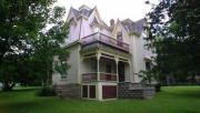
Guibourd, Jacques Dubreuil, House, northwest corner of Fourth and Merchant streets, Ste. Genevieve (5/21/69)
Kreilich Archaeological Site, address restricted (5/21/69)
Ste. Genevieve Historic District, Ste. Genevieve (10/15/66; NHL 10/09/60)
Ste. Genevieve Historic District (Historic Resources of Ste. Genevieve MPDF; map), roughly bounded by Main Street and St. Mary's Road and Roberts, Seventh and Seraphin streets, Ste. Genevieve (4/11/02)
- Saline County National Register Listings
Buckner House Arrow Rock, Arrow Rock (10/15/66; NHL 5/23/63)
Arrow Rock Ferry Landing (Historic Resources of the Santa Fe Trail - Amendment), address restricted (5/01/13)
Arrow Rock State Historic Site Bridge (ECW Architecture in Missouri State Parks, 1933-1942 TR), southeast of Arrow Rock (3/04/85)
Arrow Rock State Historic Site Grave Shelter (ECW Architecture in Missouri State Parks, 1933-1942 TR), southeast of Arrow Rock (2/27/85)
Arrow Rock State Historic Site Lookout Shelter (ECW Architecture in Missouri State Parks, 1933-1942 TR), southeast of Arrow Rock (2/27/85)
Arrow Rock State Historic Site Open Shelter (ECW Architecture in Missouri State Parks, 1933-1942 TR), southeast of Arrow Rock (2/28/85)
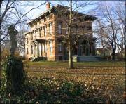
Arrow Rock Tavern, Main Street, Arrow Rock (10/15/66; NHL 2/23/72)
Baity Hall, Missouri Valley College, 500 E. College, Marshall (6/25/86)
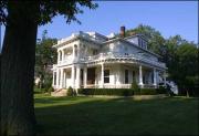
Bingham, George Caleb, House, First and High streets (10/15/66; NHL 12/21/65)
Blosser, Henry, House, east of Malta Bend off US 65 (12/29/78)
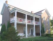
Buckner House, 125 N. Brunswick Ave., Marshall (4/19/84)
Chicago and Alton Depot, Sebree Street, Marshall (6/27/79)
First Christian Church, 400 Bridge St., Sweet Springs (9/12/80)
First Presbyterian Church (Rock Church), 212 E. North St., Marshall (9/20/77)
Fisher-Gabbert Archaeological Site, address restricted (3/16/72)
Fitzgibbon Hospital, 868 S. Brunswick Ave., Marshall (10/17/12)
Free Will Baptist Church of Pennytown, off MO UU 8 miles southeast of Marshall (4/19/88)
Gumbo Point Archaeological Site, address restricted (8/25/69)
Guthrey Archaeological Site, address restricted (12/02/70)
Mt. Carmel Historic District, 290th Road and MO Highway 41 North, Marshall vicinity (11/10/09; church destroyed by fire 5/1/2012)
Murrell, George A., House (Antebellum Resources of Johnson, Lafayette, Pettis, and Saline Counties, Missouri MPDF), 0.75 mile east and 0.5 mile north of MO E and H, Napton vicinity (11/14/97)
Neff Tavern Smokehouse, northeast of Napton off MO 41 and 6 miles west of Arrow Rock (11/30/78)
Old Fort, address restricted (1/13/72)
Plattner Archaeological Site, address restricted (3/04/71)
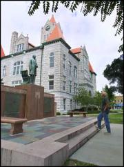
Saline County Courthouse, Courthouse Square, Marshall (8/24/77)
Santa Fe Trail - Grand Pass Trail Segments (Historic Resources of the Santa Fe Trail, 1821-1880 MPDF), junction of US 65 and Saline County Road T, Grand Pass vicinity (4/21/94)
Santa Fe Trail - Saline County Trail Segments (Historic Resources of the Santa Fe Trail, 1821-1880 MPDF), County Road 416 (Rural Route 3) west of junction with MO 41, Stanhope vicinity (6/30/94)
Sappington, William B., House, 3 miles southwest of Arrow Rock on TT (1/21/70)
Sweet Springs Historic District (Historic and Architectural Resouces of Sweet Springs, Saline County, MPDF; map) roughly along Lexington, Marshall, Miller and Spring streets, Sweet Springs (12/10/97)
Sweet Springs Historic District (Boundary Decrease; Historic and Architectural Resouces of Sweet Springs, Saline County, MPDF; map), 200-217 W. Lexington Ave. and 211 Marshall St., Sweet Springs (4/26/10)
Utz Site, Marshall vicinity (10/15/66; NHL 7/19/64; boundary revision 10/12/83)
Van Meter State Park Combination Building (ECW Architecture in Missouri State Parks, 1933-1942 TR), Marshall vicinity (2/27/85)
Van Meter State Park Shelter Building (ECW Architecture in Missouri State Parks, 1933-1942 TR), Marshall vicinity (2/28/85)
- Schuyler County National Register Listings
Downing Railroad Depot, City Park, Downing (3/29/83)
Hall, William P., House, one block west of courthouse on US 136, Lancaster (4/01/75)
- Scotland County National Register Listings
Bible Grove Consolidated District #5 School, south side of Route T at Bible Grove, Bible Grove (05/05/00)
Downing House, 311 S. Main St., Memphis (6/27/79)
Rutledge School, 142 Second St., Rutledge (1/31/17)
- Scott County National Register Listings
Anderson, Charles Isaac and Lizzie Hunter Moore, House, 203 Washington St., Commerce (6/07/06)
Brown, E. L., Village and Mound Archaeological Site, address restricted (2/12/71)
Commerce City Hall, Village Square bordered by Tywappity, Cape Girardeau, Spring and Washington, Commerce (2/02/05)
Lincoln School, 229 Westgate, Sikeston (8/14/2024)
Marshall Hotel (Dunn Hotel), 103 E. Malone, Sikeston (3/22/84)
Sandy Woods Settlement Archaeological Site, address restricted (3/04/71)
Scott County Courthouse, 131 S. Winchester St., Benton (1/28/04)
Sikeston St. Louis, Iron Mountain and Southern Railroad Depot, Sikeston (12/28/00)
- Shannon County National Register Listings
Akers Ferry Archaeological District, address restricted (10/25/90)
Alley Spring Roller Mill (Red Mill), west of Eminence off MO 106 (12/08/81)
Alley Spring State Park Historic District, Missouri Route 106 at the Jacks Fork River, Eminence vicinity (8/02/2023)
Alton Club, gravel road, 1.5 miles west of MO 19 and 12 miles north of Eminence, Eminence vicinity (10/14/05)
Buttin Rock School (Missouri Ozarks Rural Schools MPDF), east bank of Current River, south of Powder Mill Ferry, Eminence vicinity (5/31/91)
Chilton-Williams Farm Complex, east of Eminence off MO 106 (9/02/81)
Culpepper-Pummil Site, address restricted (2/03/88)
Klepzig, Walter, Mill and Farm, along Rocky Creek, Eminence vicinity (2/13/90)
Old Eminence Site, address restricted (2/04/88)
Owl's Bend Site, address restricted (5/12/88)
Pulltite Site, address restricted (2/04/88)
Reed Log House, along Current River south of Powder Mill Ferry, Eminence vicinity (4/29/91)
Rhinehart Ranch (Spring Valley Ranch), northwest of Eminence (11/14/80)
Round Spring Archaeological District, address restricted (1/25/93)
Shawnee Creek Site, address restricted (4/27/90)
Two Rivers Site, address restricted (1/23/93)
Winona Ranger Station Historic District (Historic and Architectural Resources of the Mark Twain National Forest MPDF), Route 1, MO 19N, Winona (8/04/03)
- Shelby County National Register Listings
Benjamin House Benjamin House (Vesper Place), 322 S. Shelby St., Shelbina (6/27/72)
Bethel Historic District, Bethel (11/10/70)
Elim (Dr. William Keil House), 1.5 miles east of Bethel (5/27/71)
Hebron, 0.8 mile northwest of Bethel (1/31/78)
- Stoddard County National Register Listings
Dexter Gymnasium, Park Lane and Fanetta Street, Dexter (8/8/01)
Miller, Henry, House, 106 Cape Road, Bloomfield (05/18/18)
Mingo National Wildlife Refuge Archaeology District, address restricted (5/12/75)
Rich Woods Archaeological Site, address restricted (1/25/71)
Stoddard County Courthouse, Praire and Court streets, Bloomfield (9/18/84)
- Stone County National Register Listings
Morrill, Levi, Post Office and Homestead, 2.5 miles east of MO 76 and MO 13 intersection, Notch (4/03/79)
Southwest Missouri Prehistoric Rock Shelter and Cave Sites Discontiguous Archaeological District (Prehistoric Rock Shelter and Cave Sites in Southwestern Missouri MPDF), address restricted (10/24/91)
Stone County Courthouse, Public Square, Galena (11/14/80)
Y Bridge, junction of MO 43 and 13, across the James River, Galena (5/23/91)
- Sullivan County National Register Listings
Camp Ground Church and Cemetery, west of Milan (9/23/85)
Green City Presbyterian Church, 1 East St., Green City, Sullivan County (2/10/00)
Green City Railroad Depot, 202 Lincoln St., Green City (1/15/99)
Henry Cemetery, east side of MO Z, approximately 1 mile south of Reger, Reger vicinity (12/28/05)
Milan Railroad Depot, junction of Third and Short streets, Milan (1/4/96)
Quincy, Omaha and Kansas City Railroad Office Building, 117 N. Water St., Milan (1/07/92)
- Taney County National Register Listings
Bonniebrook Homestead, 10 miles north of Branson, Walnut Shade, U.S. 65 vicinity (4/20/84)
Branson City Park Historic District (Historic Taneycomo Lakefront Tourism Resources of Branson, Taney County, Missouri MPDF), junction of St. Limas and Oklahoma streets, Branson (8/31/93; demolished 4/25/03)
Downing Street Historic District (The English Village; map), Downing Street between Third and Fourth streets, Hollister (12/29/78)
Parnell, Samuel T. and Mary B., House, 220 Angels Trail, Branson vicinity (4/25/08)
Ross, John, House (Old Matt's Cabin), west of Branson on MO 76 (7/21/83)
Sammy Lane Resort Historic District (Historic Taneycomo Lakefront Tourism Resources of Branson, Taney County, Missouri MPDF), 320 E. Main St., Branson (8/31/93; demolished 4/25/03)
Southwest Missouri Prehistoric Rock Shelter and Cave Sites Discontiguous Archaeological District (Prehistoric Rock Shelter and Cave Sites in Southwestern Missouri MPDF), address restricted (10/24/91)
Swan Creek Bridge, north of Forsyth (9/08/83; destroyed 9/28/89)
- Texas County National Register Listings
Bates-Geers House, east of Plato on Slabtown Road (9/23/82)
Cole, Arthur W., and Chloe B., House, 5803 Rocky Branch Road, Houston vicinity (12/10/98)
Houston Ranger Station Historic District (Historic and Architectural Resources of Mark Twain National Forest MPDF), 104 MO 63S, Houston (8/04/03)
Houston High School, 423 W. Pine, Houston (2/12/09)
White Rock Bluffs Archaeological Pictograph Site (23TE1), address restricted (5/21/69)
- Vernon County National Register Listings
Vernon County Courthouse Brown Archaeological Site (23VE3), address restricted (2/12/71)
Carrington Osage Village Archaeological Site (23VE1), address restricted (10/15/66; NHL 7/19/64)
Coal Pit Archaeological Site (23VE4), address restricted (2/12/71)
Halley's Bluff Site (23VE2), address restricted (7/24/74
Infirmary Building, Missouri State Hospital Number 3, 2095 N. Ash St., Nevada (11/25/05)
Prairie View Stock Farm, County Road WW, Rich Hill vicinity (9/08/15)
Vernon County Courthouse, bounded by Cherry, Cedar, Walnut and Main streets, Nevada (6/27/97)
Vernon County Jail, Sheriff's House and Office, 229 N. Main St., Nevada (8/16/77)
- Warren County National Register Listings
Borgmann Mill, 5 miles east of Marthasville off County Road D (11/10/70)
Callaway, Flanders, House, 1 mile south of Marthasville off MO 94 (7/29/69)
Fortmann, Herman H., Building, 207 Depot St., Marthasville (5/05/06)
Glosemeyer General Store, 16011 Concord Hill Road, Marthasville vicinity (1/29/18)
Marthasville Hardware Building, 203 Depot St., Marthasville (2/14/08)
Schowengerdt, Ernst, House, 308 E. Boonslick Road, Warrenton (10/03/80)
Southwestern Bell Repeater Station - Wright City, northeast corner of North Service Road and Bell Road, Wright City (2/13/07)
Starke-Meinershagen-Boeke Rural Historic District, MO 94, 5 miles west of Marthasville, Marthasville vicinity (01/07/98)
Treloar Mercantile and Farmer’s Bank of Treloar Historic District (map), 2 MKT St., Marthasville vicinity (2/16/2022)
Warren County Courthouse and Circuit Court Building, Main Street, Warrenton (3/17/72; demolished)
- Washington County National Register Listings
Caledonia Historic District (map), roughly bounded by Patrick, College and Alexander streets, and MO 21 on Main Street, Caledonia (10/27/86)
Cresswell Petroglyph Archaeological Site (23WA26), address restricted (2/12/71)
Cresswell, George, Furnance, MO F, Potosi vicinity (5/23/88)
Land Archaeological Site (23WA66 and 23WA67), address restricted (5/05/72)
Lost Creek Pictograph Archaeological Site (23WA62), address restricted (1/25/71)
Palmer Historic Mining District, address restricted, Potosi vicinity (11/29/10)
Queen, Harrison, House, Highway C, 1.3 miles west of MO 21, Caledonia vicinity (6/27/02)
Susan Cave (23WA190), address restricted. (7/08/89)
Washington County Courthouse, 102 N. Missouri St., Potosi (10/25/11)
Washington State Park CCC Historic District (ECW Architecture in Missouri State Parks, 1933-1942 TR), Potosi vicinity (3/04/85)
Washington State Park Petroglyph Archaeological Site (23WA1 and 23WA2), address restricted (4/03/70)
- Wayne County National Register Listings
Fort Benton, 3.5 miles south of junction of MO 67 and MO 34, Patterson (10/21/02)
Old Greenville (23WE637), address restricted (2/17/90)
Sam A. Baker State Park Historic District (ECW Architecture in Missouri State Parks, 1933-1942 TR), Patterson vicinity (2/27/85)
- Webster County National Register Listings
Col. Thomas C. Love House Hosmer Dairy Farm Historic District, County Farm Road 522, approximately 0.5 mile southwest of junction with MO Route E, Marshfield vicinity (5/16/96)
Love, Col. Thomas C., House, off Route 1, Seymour vicinity (1/18/85)
Rainey Funeral Home Building, 242 E. Washington St., Marshfield (1/22/14)
- Worth County National Register Listings
Worth County Courthouse, Public Square, Grant City (1/20/83)
- Wright County National Register Listings
Kelton House Administration Building, Missouri State Fruit Experiment Station, north of Mountain Grove off MO 60 (1/15/79)
Kelton House, MO 38 and Church Street, Hartville (10/02/86)
Mountain Grove Bandstand, Main and Second streets, Mountain Grove (1/19/89)
Mountain Grove City Hall, 301 E. First St., Mountain Grove (2/28/12)
Wilder, Laura Ingalls, House, 1 mile east of Mansfield on U.S. Business 60 (5/19/70; NHL 7/17/91)