


National Register Listings by County: Adair-Franklin
Hyperlinked text at the beginning of a listing goes to a word-searchable National Register nomination for that resource; other links provide maps or additional information for the resource. These items can be downloaded to your device and opened in a PDF reader.
- Adair County National Register Listings

Adair County Courthouse Adair County Courthouse, Washington Street, Kirksville (8/11/78)
Bear Creek Baptist Church, Kirksville vicinity (3/29/84)
Cabins Historic District, Novinger vicinity (7/17/79)
Dockery Hotel, Elson and McPherson streets, Kirksville (2/10/83) (destroyed 1991)
First Presbyterian Church, 201 S. High St., Kirksville (7/10/17)
Grim Building, 113-115 E. Washington St., Kirksville (6/27/79)
Harris, Capt. Thomas C, House, 1308 N. Franklin St., Kirksville (10/15/73)
Journal Printing Co. Building, 119 S. Elson St., Kirksville (7/14/11)
Kirksville Courthouse Square Historic District, 200 block North Franklin Street, 100 block East Harrison Street, 100 block West Harrison Street, Kirksville (5/21/09)
Laughlin, Drs. George and Blanche, House, 706 S. Halliburton St., Kirksville (3/11/14)
Lincoln School, 907 S. Wabash St., Kirksville (1/31/17)
Masonic Temple, 217 E. Harrison St., Kirksville, 1/07/10
St. Mary's Church, MO 11, Adair (12/16/74)
Salisbury School, MO K, Kirksville vicinity (One-Teacher Public Schools of Missouri, c. 1774 to 1973 MPDF) (10/23/2017)
Smith, Dr. E. Sanborn, House, 111 E. Patterson St., Kirksville (1/30/09)
Smith, Orie, Black and White Stock Farm Historic District, half-mile mile southeast of junction of MO Highway P and County Road 129B, Kirksville vicinity (1/16/01)
Sojourners Club, 211 S. Elson St., Kirksville (3/11/14)
Thousand Hills State Park Petroglyphs Archaeological Site, address restricted (1/23/70)
Travelers Hotel, 301 W. Washington St., Kirksville (9/16/09)
Trinity Episcopal Church, 124 N. Mulanix St., Kirksville (1/02/08)
- Andrew County National Register Listings
Andrew County Courthouse, Fourth and Main streets, Savannah (9/11/80)
Roberts, J.F., Octogonal Barn, junction of MO B and MO 48, Rea vicinity (11/18/99)
Walnut Park Farm Historic District, junction of MO 59 and MO 71, St. Joseph vicinity (12/22/99)
- Atchison County National Register Listings
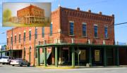
Walnut Inn and Edna O'Dell picture Atchison County Memorial Building, 417 S. Main St., Rock Port (12/22/87)
Brownville Bridge (Highway Bridges in Nebraska MPDF), U.S. 136 over the Missouri River, Phelps City vicinity (6/17/93)
Dopf, John Dickinson, Mansion, 407 Cass St., Rock Port (2/08/84)
Gibbs Site, The, address restricted (2/23/72)
Mule Barn Theatre (David Rankin Mule Barn), 10th and Park streets, Tarkio (10/15/70; destroyed by fire 2/89)
Rankin Hall, 402 N. 13th St., Tarkio (2/17/10)
St. Oswald's Protestant Episcopal Church, MO EE south of junction with MO 46, Skidmore vicinity (1/13/92)
Thompson-Campbell Farmstead, 25579 MO U, Langdon vicinity (10/18/03)
Walnut Inn (Hanna, Hunter and Co., Hannah Travis and Co., Williamson and Travis), 224 Main St., Tarkio (4/12/82)
- Audrain County National Register Listings
Audrain County Courthouse, 101 N. Jefferson St., Mexico (7/25/12)
Lincoln School, 301 Lincoln St., Vandalia (2/16/96)
Ross House, 501 S. Muldrow St., Mexico (7/26/78)
Simmons, Arthur, Stables Historic District, 621 and 701 W. Blvd., Mexico (12/04/04)
- Barry County National Register Listings
Camp Smokey/Company 1713 Historic District (ECW Architecture in Missouri State Parks, 1933-1942 TR), Cassville vicinity off Park Road (2/26/85)
Cassville Ranger Station Historic District (Historic and Architectural Resources of the Mark Twain National Forest MPDF), MO 248, Cassville (8/04/03)
Courdin House, Old, 2.4 miles southeast of Monett (11/05/71)
Downtown Monett Historic District, parts of the 200-400 blocks of Broadway and Bond, Monett vicinity (6/27/14)
McMurtry Spring and Trail of Tears Roadbed Segment (Cherokee Trail of Tears in Missouri, 1837-1839 MPDF), address restricted, Cassville vicinity (7/23/18)
Natural Bridge Archaeological Site, address restricted (5/05/72)
Roaring River Camps and Hotel Summer Cottage, 24895 Farm Road 1135, Cassville vicinity (1/4/2024)
Roaring River State Park Bath House (ECW Architecture in Missouri State Parks, 1933-1942 TR), Cassville vicinity off Park Road (3/04/85)
Roaring River State Park Dam/Spillway (ECW Architecture in Missouri State Parks, 1933-1942 TR), Cassville vicinity off Park Road (2/28/85)
Roaring River State Park Deer Leap Trail (ECW Architecture in Missouri State Parks, 1933-1942 TR), Cassville vicinity off Park Road (2/26/85)
Roaring River State Park Honeymoon Cabin (ECW Architecture in Missouri State Parks, 1933-1942 TR), Cassville vicinity off Park Road (2/26/85)
Roaring River State Park Hotel (ECW Architecture in Missouri State Parks, 1933-1942 TR), Cassville vicinity off Park Road (3/04/85)
Roaring River State Park Shelter Kitchen No. 2 and Rest Room (ECW Architecture in Missouri State Parks, 1933-1942 TR), Cassville vicinity off Park Road (2/26/85)
Southwest Missouri Prehistoric Rock Shelter and Cave Sites Discontiguous Archeological District (Prehistoric Rock Shelter and Cave and Cave Sites in Southwestern Missouri MPDF), address restricted (10/24/91)
Tom Town Historic District (map), off County Road W, south of Pleasant Ridge, Pleasant Ridge vicinity (12/15/89)
Waldensain Church and Cemetery of Stone Prairie, Route 2, Monett vicinity (1/18/85)
Wheaton Missouri and North Arkansas Railroad Depot, junction of Main and Barnett streets, Wheaton, Barry County (2/10/00)
- Barton County National Register Listings
Truman, Harry S, Birthplace Memorial, 11th Street and Truman Avenue, Lamar (6/23/69)
- Bates County National Register Listings
Bates County Courthouse, Courthouse Square, Butler (6/28/01)
Hudson City School, approximately 1 mile northwest of MO 52 and Highway W, Appleton City vicinity (10/10/02)
Palace Hotel, 2-4 W. Ohio St., Butler (7/19/02)
Papinville Marais des Cygnes River Bridge, County Road 648 over the Marais des Cygenes River, Papinville (10/22/02)
- Benton County National Register Listings
Central Cole Camp Historic District (Historic Resources of Cole Camp, Missouri MPDF) (map), Cole Camp (4/11/02)
Rogers Shelter Archaeological Site, address restricted (6/23/69)
Sander, Augustus, House (Historic Resources of Cole Camp, Missouri MPDF), 408 W. Jefferson St., Cole Camp (6/09/04)
Upper Bridge, Old Highway A, over Osage River, Warsaw vicinity (9/17/99)
- Bollinger County National Register Listings
Mayfield, Will, College Arts and Science Building, 207 Mayfield Drive, Marble Hill (5/25/05)
Mayfield, Will, College Campus, 207 Mayfield Drive, Marble Hill (1/14/2013)
- Boone County National Register Listings
Ballenger Building (Historic Resources of Downtown Columbia, Missouri MPDF), 27-29 S. Ninth St., Columbia (1/21/04)
Bond's Chapel Methodist Episcopal Church, MO A, 2.5 miles northeast of Hartsburg, Hartsburg vicinity (9/09/93)
Boone, John W. ("Blind"), House (Social Institutions of Columbia's Black Community TR), Fourth Street between East Broadway and Walnut, Columbia (9/04/80)
Central Dairy Building (Historic Resources of Downtown Columbia, Missouri MPDF), 1104-1106 E. Broadway, Columbia (1/20/05)
Chance, Albert Bishop, House and Gardens, 319 E. Sneed St., Centralia (7/03/79)
Chatol (F. Gano Chance House, Chance Guest House), 543 S. Jefferson, Centralia (4/20/79)
Coca-Cola Bottling Co. Building (Historic Resources of Downtown Columbia, Missouri MPDF), 10 Hitt St., Columbia (2/14/06)
Columbia Cemetery, 30 E. Broadway, Columbia (2/01/07)
Columbia National Guard Armory, 701 E. Ash St., Columbia (3/25/93)
Conley, Sanford F., House, 602 Sanford Place, Columbia (12/18/73)
Douglass, Fred, School (Social Institutions of Columbia's Black Community TR), 310 N. Providence Road (9/04/80)
Downtown Columbia Historic District (Historic Resources of Downtown Columbia, Missouri MPDF; map), parts of Seventh, Eighth, Ninth, 10th, East Broadway, Cherry, Hitt, Locust and East Walnut streets, Columbia (11/08/06)
Downtown Columbia Historic District (Boundary Increase) (Historic Resources of Downtown Columbia, Missouri MPDF), 1019,1020,1023 and 1025-33 E. Walnut St., Columbia (5/08/08)
East Campus Neighborhood Historic District (map), roughly bounded by Bouchelle, College, University and High streets, including parts of Willis, Bass, Dorsey and Anthony streets, Columbia (2/16/96)
Eighth Broadway Historic District [Miller Building, Matthews Hardware, Metropolitan Building], 800-810 E. Broadway Blvd., Columbia (4/22/03)
Elkins, Samuel H. and Isabel Smith, House, 315 N. 10th St., Columbia (9/12/96)
First Christian Church, 101 N. 10th St., Columbia (10/29/91)
Francis Quadrangle Historic District (Red Campus), bounded by Conley Avenue, Elm, Sixth and Ninth streets, Columbia (12/18/73)
Frederick Apartments, 1001 University Ave., Columbia (4/16/13)
Gordon, David, House and Collins Log Cabin (Gordon Manor, Fairmount, Cedar View), 2100 E. Broadway, Columbia (8/29/83)
Gordon Tract Archaeological Site, address restricted (3/16/72)
Greenwood (Greenwood Heights), 3005 Mexico Gravel Road, Columbia (1/15/79)
Guitar, David, House (Confederate Hill), 2815 Oakland Gravel Road, Columbia (9/09/93)
Hackman, Samuel E., Building, 30 S. Second St., Hartsburg (12/10/98)
Hamilton-Brown Shoe Factory, 1123 Wilkes Blvd., Columbia (7/19/02)
Harrisburg School - Ancient Landmark Masonic Lodge Number 356 A.F. & A.M., 140 S. Harris St., Harrisburg (12/24/13)
Hunt, William B., House, 8939 W. Terrapin Hills Road, Columbia vicinity (1/09/97)
Kress Building (Historic Resources of Downtown Columbia, Missouri MPDF), 1025 E. Broadway, Columbia (3/09/05)
Maplewood, Nifong Boulevard and Ponderosa Drive, Columbia (4/13/79)
McClain Furniture Store (Historic Resources of Downtown Columbia, Missouri MPDF), 916 E. Walnut, Columbia (8/17/05)
Missouri, Kansas and Texas Railroad Depot, 402 E. Broadway, Columbia (1/29/79)
Missouri State Teachers Association, 407 S. Sixth St., Columbia (9/04/80)
Missouri Theater, 201-215 S. Ninth St., Columbia (6/06/79)
Missouri United Methodist Church, 204 S. Ninth St., Columbia (9/04/80)
Mount Zion Church and Cemetery (Rural Church Architecture of Missouri, c. 1819 to c. 1945 MPDF), 11070 Mount Zion Road, Hallsville vicinity (1/14/13)
North Ninth Street Historic District (Historic Resources of Downtown Columbia, Missouri MPDF) (map), 5-36 N. Ninth St., Columbia (1/21/04)
Payne, Moses U., House, 201 N. Roby Farm Road, Rocheport vicinity (10/07/94)
Pierce Pennant Motor Hotel (Candlelight Lodge), 1406 Old Highway 40 W., Columbia (9/02/82)
Rocheport Historic District, MO 240, Rocheport (10/08/76)
St. Paul's A.M.E. Church (Social Institutions of Columbia's Black Community TR), 501 Park St. (9/04/80)
Sanborn Field and Soil Erosion Plots, University of Missouri Campus, Columbia (10/15/66; NHL 7/19/64)
Second Baptist Church (Social Institutions of Columbia's Black Community TR), 407 E. Broadway (9/04/80)
Second Christian Church (Social Institutions of Columbia's Black Community TR), 401 N. Fifth St. (9/04/80)
Senior Hall, Stephens College Campus, Columbia (8/02/77)
Sigma Alpha Epsilon Building, 24 E. Stewart Road, Columbia (10/20/14)
Stephens College, South Campus, 1200 E. Broadway, Columbia (11/25/05)
Taylor, John N. and Elizabeth, House, 716 W. Broadway, Columbia (5/25/01)
Tiger Hotel, 23 S. Eighth St., Columbia (2/29/80)
Virginia Building, 111 S. Ninth St., Columbia (3/13/02)
Wabash Railroad Station and Freight House (Norfolk and Western Depot), 126 N. 10th St., Columbia (10/11/79)
West Broadway Historic District, 300-922 W. Broadway (except 800, 808, 812), Columbia (4/27/10)
Wright Brothers Mule Barn, 1101-1107 Hinkson Ave. and 501-507 Fay St., Columbia (11/01/07)
- Buchanan County National Register Listings
Benton Club of St. Joseph, The, 402 N. Seventh St., St. Joseph (10/2/17)
Buchanan County Courthouse and Jail, Courthouse Square, St. Joseph (8/21/72; boundary decrease 8/02/78)
Buchanan County Infirmary, 3500 N. Village Drive, St. Joseph (1/29/09)
Buddy, Charles A. and Annie, House (Historic Resources of St. Joseph, Buchanan County, Missouri MPDF), 424 S. Ninth St., St. Joseph (5/14/04)
Burnside-Sandusky Gothic House, 720 S. 10th St., St. Joseph (1/19/05)
Cathedral Hill Historic District (map; Historic Resources of St. Joseph, Buchanan County, Missouri MPDF), North Ninth Street, Powell Street and North 13th Street, St. Joseph (6/15/00)
Central / North Commercial Historic District (map; Historic Resources of St. Joseph, Buchanan County, Missouri MPDF), roughly bounded by North Fourth, Main, Francis and Robidoux streets, St. Joseph (3/08/91)
Central Police Station, 701 Messanie, St. Joseph (11/05/09)
Century Apartments (Historic Resources of St. Joseph, Buchanan County, Missouri MPDF), 627 N. 25th St., St. Joseph (7/5/01)
Christian Sachau Saloon (Historic Resources of Frederick Avenue, St. Joseph MRA), 1613-1615 Frederick Ave., St. Joseph (10/25/85)
City Hose Company #9 (Historic Resources of Frederick Avenue, St. Joseph MRA), 2217 Frederick Ave., St. Joseph (10/25/85)
Corby-Forsee Building, Fifth and Felix streets, St. Joseph (3/27/80)
Dewey Avenue-West Rosine Historic District (map; Historic Resources of St. Joseph, Buchanan County, Missouri MPDF), roughly bound by Prospect Avenue, Auguste Street, Dewey Avenue and West Rosine Street, St. Joseph (8/01/02)
Eckel, Edmond Jacques, House, 515 N. Fourth St., St. Joseph (1/31/80)
Everett School (Historic Resources of St. Joseph, Buchanan County, Missouri MPDF), 826 S. 14th St., St. Joseph (9/15/05)
Fenton, Enoch Madison, House, southeast of Rushville (4/12/82; demolished)
Geiger, Dr. Jacob, House (Historic Resources of Frederick Avenue, St. Joseph MRA), 2501 Frederick Ave., St. Joseph (3/12/86)
German-American Bank Building (First Federal Building, American National Bank Building), 624 Felix St., St. Joseph (11/24/78)
Hall School, 2509 Duncan St., St. Joseph (1/31/17)
Hall Street Historic District (map), roughly bounded by Isadore, Corby, Sixth and Ninth streets, St. Joseph (7/17/79)
Harris Addition Historic District (map; Historic Resources of St. Joseph, Buchanan County, Missouri MPDF), roughly bounded by 16th, Dalton, 22nd and Edmond streets, St. Joseph (1/13/03)
Herbert, Alois, Double House (Historic Resources of St. Joseph, Buchanan County, Missouri MPDF), 620 S. 10th St., St. Joseph (5/29/07)
James, Jesse, House, 12th Street and Mitchell Avenue, St. Joseph (9/04/80)
Kelley and Browne Flats (Historic Resources of St. Joseph, Buchanan County, Missouri MPDF), 1208-1216 Frederick Ave., St. Joseph (8/03/89)
Kemper Addition Historic District (map; Historic Resources of St. Joseph, Buchanan County, Missouri MPDF), portions of Clay, Union, Kemper and Bon Ton streets, St. Joseph (9/20/02)
King's Hill Archaeological Site, St. Joseph (4/16/69)
Krug Park Place Historic District (map; Historic Resources of St. Joseph, Buchanan County, Missouri MPDF), roughly bounded by St. Joseph Avenue, Myrtle Street, Clark Street and Magnolia Avenue, St. Joseph (8/01/02)
Lawler Motor Co. Building (Historic Resources of St. Joseph, Buchanan County, Missouri MPDF), 1224 Frederick Ave., St. Joseph (1/08/09)
Livestock Exchange Building, 601 Illinois Ave., St. Joseph (listed 4/20/04; demolished 2023; delisted 1/7/25)
Logan, John Sublett Jr. and Caroline Ashton, House (Historic Resources of St. Joseph, Buchanan County, Missouri MPDF), 1906 N. 22nd St., St. Joseph (5/07/07)
"Maple Grove" (Joseph Davis House), 2100 N. 11th St., St. Joseph (10/16/74)
Market Square Historic District (map), roughly bounded by Edmond, Felix and North Third streets, and Market Place, St. Joseph (2/17/72)
McIntyre-Burri House (Historic Resources of St. Joseph, Buchanan County, Missouri MPDF), 808 N. 24th St., St. Joseph (12/23/05)
Miller, Issac, House, 3003 Ashland Ave., St. Joseph (9/17/80)
Miller-Porter-Lacy House, 2912 Frederick Blvd., St. Joseph (9/09/82)
Missouri Theater and Missouri Theater Building, 112-128 S. Eighth and 713-721 Edmond St., St. Joseph (10/11/79)
Missouri Valley Trust Company Historic District, Felix and Fourth streets, St. Joseph (3/04/75)
Mount Mora Cemetery, 824 Mount Mora Road, St. Joseph (7/19/06)
Museum Hill Historic District (map; Historic Resources of St. Joseph, Buchanan County, Missouri MPDF), roughly bounded by Ninth, Francis, 12th, Jules, 15th and Messanie streets, St. Joseph (3/08/91)
Museum Hill Historic District (Boundary Increase; Historic Resources of St. Joseph, Buchanan County, Missouri MPDF), 321 and 323 N. 15th and 1510 Faraon St., St. Joseph (8/05/09)
Neely Elementary School, 1909 S. 12th St., St. Joseph (6/23/14)
Nelson-Pettis Farmsteads Historic District, 4401 Ajax Road, 3412 Pettis Road, St. Joseph (5/11/95)
Patee John, House, 12th and Penn streets, St. Joseph (10/15/66; NHL 11/05/61)
Patee Town Historic District (map; Historic Resources of St. Joseph, Buchanan County, Missouri MPDF), roughly bounded by Penn, South 11th, Lafayette and South 15th streets, St. Joseph (8/01/02)
Pleasant Ridge School, St. Joseph vicinity (5/02/85)
Pony Express Stables (Pike's Peak Stables), 914 Penn St., St. Joseph (4/03/70)
Richardson, John D., Dry Goods Co. (American Electric Co.), 300 N. Third St., St. Joseph (4/12/82)
Robidoux Hill Historic District (map; Historic Resources of St. Joseph, Buchanan County, Missouri MPDF), roughly bounded by Franklin, Robidoux, Fourth, Louis and Fifth streets, St. Joseph (8/03/89)
Robidoux Row, 219-225 E. Poulin St., St. Joseph (3/07/73)
Robidoux School (Junior College Archive Building), 201 S. 10th St., St. Joseph (8/11/83)
Ryan Block (Historic Resources of St. Joseph, Buchanan County, Missouri MPDF), 1137-1141 Frederick Ave., St. Joseph (1/29/13)
St. Joseph City Hall (Historic Resources of Frederick Avenue, St. Joseph MRA), Frederick at 11th Street, St. Joseph (10/25/85)
St. Joseph Park and Parkway System (Historic Resources of St. Joseph, Buchanan County, Missouri MPDF), roughly along Northwest, Northeast, Corby Grove, Southwest and A parkways and Noyes Boulevard from Krug Park to Hyde Park, St. Joseph (1/20/95)
St. Joseph Public Library-Carnegie Branch, 316 Massachusetts St., St. Joseph (5/20/99)
St. Joseph Public Library (Free Public Library, Public Museum, Public Library, Board of Education Building), 10th and Felix streets, St. Joseph (9/20/82)
St. Joseph's Commerce and Banking Historic District (map; Historic Resources of St. Joseph, Buchanan County, Missouri MPDF), roughly bounded by Francis, Edmond, Third and Ninth streets, St. Joseph (7/5/01)
South Fourth Street Commercial Historic District (map; Historic Resources of St. Joseph, Buchanan County, Missouri MPDF), roughly bounded by South Third, South Fifth, Charles and Messanie streets, St. Joseph (3/08/91)
Sugar Lake State Park Open Shelter (ECW Architecture in Missouri State Parks, 1933-1942 TR), Rushville vicinity off MO 138 (2/28/85)
Thompson-Brown-Sandusky House, 207 E. Cliff St., St. Joseph (2/10/83)
Virginia Flats, 516-518 and 520-528 N. 10th St., St. Joseph (5/21/92)
Vosteen-Hauck House, 913 N. Second St., St. Joseph (9/23/82)
Western Tablet and Stationery Co., Building #2 (Historic Resources of St. Joseph, Buchanan County, Missouri MPDF), 1300 S. 12th St., St. Joseph (8/16/07)
Wholesale Row (map), bounded by Jules, Third, Fourth and Francis streets, St. Joseph (9/19/77)
Wyeth Flats (Historic Resources of Frederick Avenue, St. Joseph MRA), San Regis Apartments, 1015-1031 Faraon, St. Joseph (10/25/85)
- Butler County National Register Listings
Butler County Courthouse (Historic Resources of Poplar Bluff, Missouri MPDF), Public Square, Poplar Bluff (12/01/94)
Cynthia-Kinzer Historic District, 900-1000 blocks of Cynthia and Kinzer, 918-924 Maud and 838-842 Kinzer streets, Poplar Bluff (7/21/15)
Garfield Historic District, 914-916, 915, 921 Garfield St., Poplar Bluff (10/2/17)
Greer, Alfred W., House, 955 Kinzer St., Poplar Bluff (2/12/98)
Hargrove Pivot Bridge, County Road 159 over Black River, Poplar Bluff vicinity (10/15/85)
Koehler Fortified Archaeological Site, address restricted (12/18/70)
Little Black River Archaeological District, address restricted (4/21/75)
Mark Twain School, (Historic Resources of Poplar Bluff, Missouri MPDF), 1012 N. Main St., Poplar Bluff (2/05/98)
Moore-Dalton House (Historic Resources of Poplar Bluff, Missouri MPDF), 421 N. Main St., Poplar Bluff (12/01/94)
Moore, J. Herbert, House, 445 N. 11th St., Poplar Bluff (12/12/98)
Moore, Thomas, House, 435 Lester St., Poplar Bluff (2/12/98)
North Main Street Historic District (Historic Resources of Poplar Bluff, Missouri MPDF; map), 400 block of North Main Street, Poplar Bluff (7/14/11)
Phillips, John Archibald, House, 522 Cherry St., Poplar Bluff (2/12/98)
Poplar Bluff Commercial Historic District (Historic Resources of Poplar Bluff, Missouri MPDF; map), roughly South Broadway from Cedar Street to Vine Street, and Vine from Fifth Street to South Broadway, Poplar Bluff (12/01/94)
Poplar Bluff Public Library (Historic Resources of Poplar Bluff, Missouri MPDF), 318 N. Main St., Poplar Bluff (12/01/94)
Rodgers Theatre Building, 204-224 N. Broadway, Poplar Bluff (7/19/01)
South Sixth Street Historic District, 205-225-303 S. Sixth St., Poplar Bluff (2/12/98)
St. Louis, Iron Mountain and Southern Railroad Depot (Historic Resources of Poplar Bluff, Missouri MPDF), 400 S. Main St., Poplar Bluff (12/01/94)
St. Louis-San Francisco Railroad Depot (Historic Resources of Poplar Bluff, Missouri MPDF), 303 Moran St., Poplar Bluff (12/01/94)
Wheatley Public School, 921 Garfield St., Poplar Bluff (2/13/98)
Wilborn-Steinberg Site, address restricted (11/09/72)
Williams-Gierth House (Poplar Bluff MPS), 848 Vine St., Poplar Bluff (11/06/12)
Williamson-Kennedy School, 614 Lindsay St., Poplar Bluff (2/12/98)
Wright-Dalton-Bell-Anchor Department Store Building (Historic Resources of Poplar Bluff, Missouri MPDF), 201-205 S. Main, Poplar Bluff (4/12/06)
Zehe Building, (Historic Resources of Poplar Bluff, Missouri MPDF), 203 Poplar St., Poplar Bluff (12/01/94)
- Caldwell County National Register Listings
Caldwell County Courthouse, Main Street, Kingston (1/13/72)
Far West, 5.5 miles west of Kingston by county roads D and H (9/22/70)
Switzer, P.A., Residence, 211 E. Samuel St., Hamilton (1/4/2024)
- Callaway County National Register Listings
Bell, M. Fred, Rental Cottage, 302 E. Fifth St., Fulton (7/10/97)
Bell, M. Fred, Speculative Cottage, 304 E. Fifth St., Fulton (6/30/95)
Brandon-Bell-Collier House, 207 W. Ninth St., Fulton (12/24/98)
Carver, George Washington, School, 909 Westminster, Fulton (12/02/96)
Cote Sans Dessein Archaeological Site, address restricted (5/27/71)
Court Street Historic Residential District, roughly along Court between St. Louis and 10th streets, Fulton, (8/15/07)
Downtown Fulton Historic District (map), roughly bounded by Fourth Street, Market, Seventh Street and Jefferson Avenue, Fulton (7/07/04)
Hockaday, John Augustus, House, 105 Hockaday Ave., Fulton (9/17/80)
Mealy Mounds Archaeological Site, address restricted (1/25/71)
Middle River School (One-Teacher Public Schools of Missouri, c. 1774-1973 MPDF), 6587 County Road 305, Fulton vicinity (4/1/2024)
Moore's Mill Battlefield, address restricted (5/04/15)
Oakley Chapel African Methodist Episcopal Church, County Road 485 at junction of County Road 486, Tebbetts vicinity (12/17/08)
Pitcher Store, 8513 Pitcher Road, Fulton (3/12/2001; proposed relocation approved 10/17/03)
Research Cave, address restricted (10/15/66; NHL 7/19/64)
Richland Christian Church, 5301 County Road 220, Fulton vicinity (2/16/01)
Robnett-Payne House, 601 W. Sixth St., Fulton (9/17/98; request for relocation approved 5/24/01)
Westminster College Gymnasium, Westminster College campus, Fulton (5/23/68; NHL 5/10/68)
Westminster College Historic District, off Westminster Avenue, Fulton (4/12/82)
White Cloud Presbyterian Church and Cemetery, south side state Route F at intersection with County Road 232, Fulton vicinity (10/12/10)
Willing, Dr. George M., House, 211 Jefferson St., Fulton (10/03/80)
Winston Churchill Memorial, Seventh Street and Westminster Avenue, Fulton (3/16/72)
- Camden County National Register Listings
Camp Hawthorne Central Area District (ECW Architecture in Missouri State Parks, 1933-1942 TR), northeast of Camdenton off Highway 42 (2/28/85)
Camp Pin Oak Historic District (ECW Architecture in Missouri State Parks, 1933-1942 TR), northeast of Camdenton off Highway 42 (6/27/85)
Lake of the Ozarks State Park Camp Clover Point Recreation Hall (ECW Architecture in Missouri State Parks, 1933-1942 TR), northeast of Camdenton off Highway 42 (3/04/85)
Lake of the Ozarks State Park Camp Rising Sun Recreation Hall (ECW Architecture in Missouri State Parks, 1933-1942 TR), northeast of Camdenton off Highway 42 (3/04/85)
Lake of the Ozarks Recreational Demonstration Area Barn/Garage in Kaiser Area (ECW Architecture in Missouri State Parks 1933-1942 TR), northeast of Camdenton off Highway 42 (2/28/85)
Lake of the Ozarks Recreational Demonstration Area Rising Sun Shelter (ECW Architecture in Missouri State Parks, 1933-1942 TR), northeast of Camdenton off Highway 42 (2/26/85)
Lake of the Ozarks Recreational Demonstration Area Shelter at McCubbin Point (ECW Architecture in Missouri State Parks, 1933-1942 TR), northeast of Camdenton off MO A (2/26/85)
Pin Oak Hollow Bridge (ECW Architecture in Missouri State Parks, 1933-1942 TR), Pin Oak Hollow, Kaiser vicinity (9/13/85)
Urbauer Fishing Lodge Historic District, 442 Riverbird Lane, Camdenton vicinity (11/08/06)
- Cape Girardeau County National Register Listings
Bainbridge Ferry (Historic and Historical Archaeological Resources of the Cherokee Trail of Tears MPDF), County Road 630, Cape Girardeau vicinity (6/21/07)
Bainbridge Ferry Road (Historic and Historical Archaeological Resources of the Cherokee Trail of Tears MPDF), County Road 623, Cape Girardeau vicinity (6/21/07)
Bennett-Tobler-Pace-Oliver House, 224 E. Adams, Jackson (4/18/85)
Big Hill Farmstead Historic District, 2246 MO PP, Jackson vicinity (12/22/99)
B'Nai Israel Synagogue, 126 S. Main, Cape Girardeau (5/05/04)
Bollinger Mill, off MO 34, Burfordville (5/27/71)
Broadway and North Fountain Street Historic District (Historic and Architectural Resources of Cape Girardeau, Missouri MPDF; map), 320-400 Broadway and 221 N. Fountain St., Cape Girardeau (7/15/03)
Broadway Commercial Historic District, 600, 700 and 800 blocks of Broadway and 210 N. Ellis St., Cape Girardeau (9/06/16)
Broadway-Middle Commercial Historic District (Historic and Architectural Resources of Cape Girardeau, Missouri MPDF), 500 block of Broadway and 100 block of North Middle Street, Cape Girardeau (7/24/07)
Broadway-Middle Commercial Historic District (boundary increase; Historic and Architectural Resources of Cape Girardeau, Missouri MPDF), south side 400 block of Broadway, Cape Girardeau (9/04/13)
Broadway Theatre, 805 Broadway, Cape Girardeau (6/15/15)
Burfordville Covered Bridge, east edge of Burfordville on County Road HH (5/19/70)
Byrd, Abraham, House, 2832 County Road 442, Jackson vicinity (6/21/07)
Cape Girardeau Commercial Historic District (map; Historic and Architectural Resources of Cape Girardeau, Missouri MPDF), 100 block of North Main Street and 100 block of Broadway, Cape Girardeau (7/20/00)
Cape Girardeau Commercial Historic District (Boundary Increase; map; Historic and Architectural Resources of Cape Girardeau, Missouri MPDF), 101 N. Main St., Cape Girardeau, (7/11/07)
Cape Girardeau Commercial Historic District (Boundary Increase II; Historic and Architectural Resources of Cape Girardeau, Missouri MPDF), 127 N. Water St., Cape Girardeau (8/29/08)
Cape Girardeau Court of Common Pleas, 44 N. Lormier, Cape Girardeau (10/25/10)
Central High School, 101 S. Pacific St., Cape Girardeau (7/18/08)
Chapman, Dr. Jean, House, 1150 N. Henderson Ave., Cape Girardeau (3/15/16)
Clark, George Boardman, House, 6 S. Fountain St., Cape Girardeau (7/22/94)
Courthouse-Seminary Neighborhood Historic District, roughly bounded by Middle, Themis, Main, Aquamsi and Morgan Oaks streets, Cape Girardeau (9/09/10)
Erlbacher Buildings, 1105 and 1107 Broadway, Cape Girardeau (7/08/09)
Esquire Theater (Historic and Architectural Resources of Cape Girardeau, Missouri MPDF), 824 Broadway, Cape Girardeau (9/15/05)
First Baptist Church, 200 Broadway St., Cape Girardeau (6/27/2023)
Fort D Historic District (map), 920 Fort St., Cape Girardeau (8/1/2019)
Frizel-Welling House, 209 W. Main St., Jackson (6/25/99)
Glenn House, 325 S. Spanish St., Cape Girardeau (10/11/79)
Green's Ferry (Historic and Historical Archaeological Resources of the Cherokee Trail of Tears MPDF), address restricted, Cape Girardeau vicinity (6/21/07)
Haarig Commercial Historic District (Historic and Architectural Resources of Cape Girardeau, Missouri MPDF; map), along sections of the 600 block of Good Hope Street and 300 block of South Sprigg Street, Cape Girardeau (7/20/00)
Hanover Lutheran Church, 2949 Perryville Road, Cape Girardeau (9/14/87)
Harrison, William Henry and Lilla Luce, House, 313 Themis St., Cape Girardeau (12/06/05)
Himmelberger and Harrison Building (Historic and Architectural Resources of Cape Girardeau, Missouri MPDF), 400 Broadway, Cape Girardeau (7/17/03)
House at 323 Themis Street, 323 Themis St., Cape Girardeau (6/27/97)
Huhn-Harrison House, 340 S. Lorimier St., Cape Girardeau (6/27/02)
Jackson Uptown Commercial Historic District, roughly bounded by Court, Main, Missouri and High streets, Jackson (2/01/06)
Jefferson School, 731 Jefferson Ave., Cape Girardeau (5/12/09)
Kage School, 3110 Kage Road, Cape Girardeau (9/29/05)
Klostermann Block, 7, 9, 11, 13 and 15 S. Spanish St., Cape Girardeau (7/22/94)
Lilly, Edward S. and Mary Annatoile Albert, House, 129 S. Lorimier, Cape Girardeau (6/20/08)
Main-Spanish Commercial Historic District (Historic and Architectural Resources of Cape Girardeau, Missouri MPDF), roughly the 100 blocks of Main and Spanish streets and adjacent portions of Themis and Independence, Cape Girardeau (12/30/08)
Marquette Hotel, 338 Broadway St., Cape Girardeau (4/11/02)
McKendree Chapel, off Interstate 55, Jackson vicinity (4/13/87)
McKendree Chapel (Boundary Increase), south side Bainbridge Road, 0.5 mile west of I-55 (2/14/06)
Miller-Seabaugh House and Dr. Seabaugh Office Building, 341 Market St., Millersville (1/4/96)
Old Appleton Bridge, Main Street over Apple Creek, Old Appleton (8/25/09)
Old Lorimier Cemetery, 500 N. Fountain, Cape Girardeau (9/28/05)
Oliver-Leming House, 740 North St., Cape Girardeau (9/12/80)
Ponder, Abraham Russell, House, 141 S. Louisiana Ave., Cape Girardeau (3/27/08)
Pott, Fredrick W. and Mary Karau, House, 826 Themis St., Cape Girardeau (6/25/99)
Reynolds, James, House, 623 N. Main St., Cape Girardeau (10/13/83)
St. James A.M.E. Church, 516 North St., Cape Girardeau (1/15/14)
St. Vincent de Paul Catholic Church, 131 S. Main St., Cape Girardeau (4/12/82)
St. Vincent's College Building, 201 Morgan Oak St., Cape Girardeau (9/30/05)
Shady Grove Cemetery, 502 County Road 211, Gordonville vicinity (6/27/2022)
Shivelbine, August and Amalia, House, 303 S. Spanish St., Cape Girardeau (6/25/99)
South Middle Street Historic District, 513 William St., 202-230 S. Middle St. and 203-229 S. Middle, Cape Girardeau (10/14/09)
Southeast Missourian Building (Historic and Architectural Resources of Cape Girardeau, Missouri MPDF), 301 Broadway, Cape Girardeau (6/01/05)
Thilenius, The Col. George C., House, 100 Longview Place, Cape Girardeau (4/14/83)
Trail of Tears State Park Archaeological Site, address restricted (12/02/70)
Turner Hall (Historic and Architectural Resources of Cape Girardeau, Missouri MPDF), 300 Broadway St., Cape Girardeau (4/14/2025)
Vasterling, Julius, Building (Historic and Architectural Resources of Cape Girardeau, Missouri MPDF), 633-637 Broadway, Cape Girardeau (6/17/09)
Warehouse Row Historic District (Historic and Architectural Resources of Cape Girardeau, Missouri MPDF), 19 N. Water St., Cape Girardeau (12/4/04)
Wichterich, Robert Felix and Elma Taylor, House, 300 Good Hope St., Cape Girardeau (8/12/99)
Wilson, J. Maple and Grace Senne, House, 344 N. Ellis St., Cape Girardeau (7/7/15)
Wood Building (Historic and Architectural Resources of Cape Girardeau, Missouri MPDF), 1-3 S. Frederick and 605-607 Independence streets, Cape Girardeau (12/10/03)
- Carroll County National Register Listings
Carroll County Court House, Courthouse Square, Carrollton (7/21/95)
Carroll County Sheriff's Quarters and Jail, 101 Washington St., Carrollton (10/11/79)
Farmers Bank Building, 114 S. Pine St., Norborne (7/07/94)
U.S. Post Office, 101 N. Folger St., Carrollton (5/12/77)
Wilcoxson and Company Bank (Farmer's Bank of Carrolton, Farmer's Bank of Bogard), 1 W. Washington Ave., Carrollton (1/21/83)
Wright II Archaeological Site, address restricted (5/27/71)
- Carter County National Register Listings
Bedell, Mrs. Louis, House (Missouri Lumber and Mining Company Historic Resources MRA), Third and Maple streets, Grandin (10/14/81)
Boyer, Earl, House (Missouri Lumber and Mining Company Historic Resources MRA), Fifth Street, Grandin (10/14/81)
Big Spring Historic District, east of Van Buren on MO 103 (3/17/81)
Carter County Courthouse, 105 Main St., Van Buren (10/06/2022)
Chubb Hollow Site, address restricted (1/18/90)
Gibson, J. W., House (Missouri Lumber and Mining Company Historic Resources MRA), Sixth and Pine streets, Grandin (10/14/81)
Gooseneck Site, address restricted (10/02/90)
Greensfelder, Delia, House (Missouri Lumber and Mining Company Historic Resources MRA), Fourth and North Cherry streets, Grandin (10/14/81)
Herrington, Loretta, House (Missouri Lumber and Mining Company Historic Resources MRA), Fifth Street, Grandin (10/14/81)
Hinton, James, House (Missouri Lumber and Mining Company Historic Resources MRA), Walnut Street, Grandin (10/14/81)
Jacobson, Nettie, House (Missouri Lumber and Mining Company Historic Resources MRA), Sixth and Oak streets, Grandin (10/14/81)
Kelley, Issac, Site, address restricted (2/04/88)
Kitterman, Nola, House (Missouri Lumber and Mining Company Historic Resources MRA), Sixth Street, Grandin (10/14/81)
Knapp, Wallace, House (Missouri Lumber and Mining Company Historic Resources MRA), Sixth and South Elm streets, Grandin (10/14/81)
Lawhorn, Buford, House (Missouri Lumber and Mining Company Historic Resources MRA), Sixth Street, Grandin (10/14/81)
Lewis, Iva, House (Missouri Lumber and Mining Company Historic Resources MRA), Sixth Street, Grandin (10/14/81)
Masonic Lodge (Missouri Lumber and Mining Company Historic Resources MRA), Fifth and South Elm streets, Grandin (10/14/81)
Mays, Terry, House (Missouri Lumber and Mining Company Historic Resources MRA), Sixth and South Plum streets, Grandin (10/14/81)
McNew, Thornton, House (Missouri Lumber and Mining Company Historic Resources MRA), Sixth and Spruce streets, Grandin (10/14/81)
Mill Pond (Missouri Lumber and Mining Company Historic Resources MRA), off MO 21, Grandin (10/14/81)
Nance, Della, House (Missouri Lumber and Mining Company Historic Resources MRA), Sixth Street, Grandin (10/14/81)
Owens, Hazel, House (Missouri Lumber and Mining Company Historic Resources MRA), Fifth Street, Grandin (10/14/81)
Phillips Bay Mill, address restricted (2/03/88)
Phillips, Ernie, House (Missouri Lumber and Mining Company Historic Resources MRA), Third and North Cherry streets, Grandin (10/14/81)
Powers, Alvis, House (Missouri Lumber and Mining Company Historic Resources MRA), Walnut Street, Grandin (10/14/81)
Shoat, Hazel, House (Missouri Lumber and Mining Company Historic Resources MRA), Fifth Street, Grandin (10/14/81)
Sixth Street Historic District (Missouri Lumber and Mining Company Historic Resources MRA), Sixth Street, Grandin (10/14/81)
Smith, James, House (Missouri Lumber and Mining Company Historic Resources MRA), Sixth Street, Grandin (10/14/81)
Smith, Lawrence, House (Missouri Lumber and Mining Company Historic Resources MRA), Third Street, Grandin (10/14/81)
Smith, William F., House (Missouri Lumber and Mining Company Historic Resources MRA), Sixth Street, Grandin (10/14/81)
Tucker, Lee, House (Missouri Lumber and Mining Company Historic Resources MRA), Third Street, Grandin (10/14/81)
- Cass County National Register Listings
Brown, Robert A., House, north of Harrisonville off U.S. 71 (6/15/70)
Watkins Family Farm Historic District, 19116 S. School Road,
Harrisonville Courthouse Square Historic District (map), roughly, Courthouse Square and adjacent side streets, Harrisonville (4/08/94)
O'Bannon Homestead (Schuyler Stock Farm), northeast of Garden City off MO NN (7/03/79)
Pleasant Hill Downtown Historic District (map), approximately bounded by the 200 block of Cedar Street, 100 block of Lake Street, 100-115 Wyoming St. and 101-204 First St., Pleasant Hill (3/23/05)
St. Peter's Episcopal Church, 400 W. Wall St., Harrisonville (9/09/82)
Stumbaugh Post No. 180 G.A.R. Hall, Missouri Highway T, Austin (6/8/00)
- Cedar County National Register Listings
Caplinger Mills Historic District (map), junction of Washington Avenue and the Sac River, Caplinger Mills (9/02/93)
Montgomery Archaeological Site, address restricted (9/21/78)
Stockton Community Building, junction of Spring and Morth streets, Stockton (12/10/98)
- Chariton County National Register Listings
Chariton County Courthouse, State Street, Keytesville (11/19/71) (destroyed by fire 8/27/73)
Chariton County Jail and Sheriff's Residence, 305 S. Cherry, Keytesville (1/16/97)
Dalton Vocational School Historic District (map), junction of Fourth Street and MO J, Dalton vicinity (08/05/02)
First Presbyterian Church, Hill and East streets, Keytesville (11/23/77)
Locust Hill, east of Brunswick on State Road Y (1/10/80)
Redding-Hill House, 100 W. North St., Keytesville (7/29/69)
Salisbury Square Historic District, 402, 404, 406, 407, 408, 502, 504, 506, 508 S. Broadway, Salisbury (6/11/09)
Thomas, Fabrishous and Sarah A., House, 302 E. Second St., Salisbury (6/25/99)
- Christian County National Register Listings
Ozark Courthouse Square Historic District, portions of Second Avenue, Church, Elm and Second streets on the Courthouse Square, Ozark (2/05/09)
Smallin Cave Historic District, 3575 N. Smallin Road, Ozark vicinity (3/08/2018)
Southwest Missouri Prehistoric Rock Shelter and Cave Sites Discontiguous Archeological District (Prehistoric Rock Shelter and Cave Sites in Southwestern Missouri MPDF), address restricted (10/24/91)
Wilson's Creek National Battlefield, southwest of Springfield on MO 174 (10/15/66)
- Clark County National Register Listings
Boulware Mound Group Archaeological Site, address restricted (1/21/70)
Clark County Courthouse, 101 E. Court St., Kahoka (9/08/83)
Hiller, Colonel Hiram M., House, 570 N. Washington, Kahoka (7/21/86)
Montgomery Opera House, 201-209 W. Commercial St., Kahoka (10/20/88)
Shrine of St. Patrick Church, Erin Circle, St. Patrick (determined eligible 2/27/07)
Sickles Tavern, northwest of Wayland on MO B (10/22/79)
- Clay County National Register Listings
Aker Cemetery, northeast of Smithville off MO W (11/13/74)
Antioch Christian Church, 4805 NE Antioch Road, Kansas City (4/02/79)
Armour Theatre Building, 400-410 Armour Road, North Kansas City (6/24/08)
Arthur-Leonard Historic District (Historic Resources of Liberty MPDF; map), roughly bounded by Ford Avenue, Jewell, Choctaw, and Missouri streets, Liberty (1/4/01)
Atkins-Johnson Farmhouse Property, 6508 N. Jackson Ave., Gladstone (11/07/07)
Boarding House District (Historic Resources of Excelsior Springs, Missouri MPDF), 401-608 Benton, 339-436 E. Broadway, 201-223 S. Francis, 105 Haynes, 309-526 Isley, 101 Linden, 110-112 Perry, 103-305 Saratoga, 000-213 Temple, Excelsior Springs (8/24/18)
Clay County Savings Association Building (Historic Resources of Liberty MPDF), 104 E. Franklin, Liberty (12/28/92)
Claybrook House, Kearney vicinity (12/21/81)
Clinton House, 404 S. Leonard St., Liberty (11/22/78)
Colonial Hotel, 328 E. Broadway, Excelsior Springs (6/24/10)
Compton, Dr. James, House, 5410 NE Oak Ridge Road, Kansas City (7/10/79)
Dougherty-Prospect Heights Historic District (Historic Resources of Liberty MPDF; map), roughly bounded by Mississippi, Gallatin and Schrader streets and Fairview Avenue, Liberty (1/4/01)
Downtown Smithville Historic District, roughly bounded by Bridge, Church, Commercial and Meadow streets, Smithville (4/21/14)
Elms Hotel, Regent and Elms Boulevard, Excelsior Springs (3/29/85)
Elms, The, Historic District (Historic Resources of Excelsior Springs, Missouri MPDF), roughly 400 block of Regent Avenue, 500 block of Elms Boulevard, 500-600 blocks of Kansas City Avenue, Excelsior Springs (3/31/14)
Excelsior Springs Hall of Waters Commercial East Historic District, roughly along portions of East and West Broadway and Main Street, Excelsior Springs (5/27/99)
Excelsior Springs Hall of Waters Commercial West Historic District, roughly along portions of Thompson and St. Louis avenues; South, Main, Marietta and Spring streets, and Elm Boulevard, Excelsior Springs (5/27/99)
First Methodist Church, 114 N. Marietta St., Excelsior Springs (10/28/09)
Garrison School Historic District (Historic Resources of Liberty MPDF; map), roughly along North Main and North Water streets, Liberty (1/4/01)
Hall of Waters (Siloam Park and Springs; map), 201 E. Broadway, Excelsior Springs (6/09/83)
Hughes, Frank, Memorial Library (Historic Resources of Liberty MPDF), 210 E. Franklin, Liberty (12/28/92)
IOOF Liberty Lodge #49 (Historic Resources of Liberty MPDF), 16-18 E. Franklin, Liberty (12/28/92)
James Brothers' House and Farm (Birthplace of Jesse James), 2.25 miles northeast of Kearney (3/16/72); Boundary Increase (9/27/78)
Jewell Hall, Jewell Street between Kansas and Mississippi streets, Liberty (9/06/78)
Jewell-Lightburne Historic District (Historic Resources of Liberty MPDF; map), roughly bounded by North Jewell, East Mill, Main and Gordon streets, Liberty (1/4/01)
Ligon Apartments, 211 E. Excelsior St., Excelsior Springs (5/17/10)
Major Hotel (Historic Resources of Liberty MPDF), 112 E. Franklin, Liberty (12/28/92)
Miller Building (Historic Resources of Liberty MPDF), 2 E. Franklin, Liberty (12/28/92)
Missouri City Savings Bank Building and Meeting Hall, 417-419 Main St., Missouri City (7/30/10)
Mt. Memorial Cemetery, 500 block of East Mississippi Street, Liberty (4/24/12)
Nebo Hill Archaeological Site, address restricted (3/04/71)
Odd Fellows Home District (map), MO 291, Liberty (9/15/87)
Sears, Roebuck and Co. Warehouse Building, 715 Armour Road, North Kansas City (5/09/97)
South Liberty Courthouse Square Historic District (Historic Resources of Liberty MPDF; map), South Main and East Kansas streets, Liberty (12/28/92)
Watkins Mill, 6 miles northwest of Excelsior Springs (11/13/66; NHL 11/13/66, updated NHL 9/2/24)
West Liberty Courthouse Square Historic District (Historic Resources of Liberty MPDF; map), North Main Street, Liberty (12/28/92)
Wheeling Corrugating Co. Building, 820 E. 14th Ave., North Kansas City (10/21/94)
Woodneath (Eldridge Arnold Homestead), 8900 NE Flintlock Road, Kansas City (2/17/78)
Wyman School, 100 Dunbar St., Excelsior Springs (7/24/08)
- Clinton County National Register Listings
Stoutimore, David L. and Saline Ann, House Stoutimore, David L. and Sallie Ann, House, 501 S. Birch Ave., Plattsburg (7/23/2013)
- Cole County National Register Listings
Bolton, Lewis, House, 9514 MO W, Wardsville (8/20/99)
Bockrath, Henry and Elizabeth, House (Historic Southside (Munichburg) MPDF), 309 W. Dunklin St., Jefferson City (4/23/13)
Broadway-Dunklin Historic District (Historic Southside (Munichburg) MPDF; map), most of 600 block of Broadway, and the 200 and 300 blocks of West Dunklin Street, Jefferson City (11/14/02)
Burch, Nelson C. and Gertrude A., House (Historic Southside (Munichburg) MPDF), 115 W. Atchison St., Jefferson City (1/08/03)
Burch, Oscar G. and Mary H., House (Historic Southside (Munichburg) MPDF), 924 Jefferson St., Jefferson City (11/15/02)
Capitol Avenue Historic District, roughly Capitol Avenue, from Adams Street to Cherry Street, Jefferson City (12/28/05)
Cole County Courthouse and Jail-Sheriff's House, Monroe and East High streets, Jefferson City (4/03/73)
Cole County Historical Society Building, 109 Madison St., Jefferson City (5/21/69)
Dulle Farmstead Historic District, 1101 Highway 54 W., Jefferson City (12/30/93)
East End Drugs, 630 E. High St., Jefferson City (8/21/03)
Garnett Farm Historic District, 7119 MO 179, Centertown vicinity (5/31/16)
Gay Archaeological Site, address restricted (1/25/71)
Gensky, H. E., Grocery Store Building, 423 Cherry St., Jefferson City (6/6/01)
Grove, Claud D. and Berenice Sinclair Grove House, 505 E. State St., Jefferson City (11/14/02)
Haar, Herman, House, 110 Bolivar St., Jefferson City (5/02/97)
Hess, Philip, House (Historic Southside (Munichburg) MPDF), 714 Washington St., Jefferson City (11/15/02)
Hobo Hill Historic District, 500 blocks of East Miller and Jackson streets, Jefferson City (1/02/13)
International Shoe East End-Main Street Factory, 1101 E. Capitol Ave., Jefferson City (2/1/2021)
Ivy Terrace (Governor Lon Vest Stephens House), 500 E. Capitol Ave., Jefferson City (3/16/90)
J.B. Bruns Shoe Company Building, 627 W. McCarty St., Jefferson City (2/26/2021)
Jefferson City Community Center, 608 E. Dunklin St., Jefferson City (5/14/92)
Jefferson City National Cemetery (Civil War Era National Cemeteries MPDF), 1024 E. McCarty St., Jefferson City (10/01/98)
Jefferson Female Seminary, 416 and 420 E. State St., Jefferson City (2/24/00)
Kaullen Mercantile Co., 900 and 902 E. High St., Jefferson City (11/21/02)
Lansdown-Higgins, House, 5240 Tanner Bridge Road, Jefferson City vicinity (11/12/99)
Lincoln University Hilltop Campus Historic District (map), 820 Chestnut St., Jefferson City (4/28/83)
Lincoln University Hilltop Campus Historic District (Boundary Increase; map), 820 Chestnut St., Jefferson City (8/21/02)
Lohman's Landing Building, Jefferson and Water streets, Jefferson City (2/25/69)
Miller, Frank, Green Berry Road Historic District (map), 1427, 1431 and 1503 Green Berry Road, Jefferson City (3/21/2022)
Missouri Governor's Mansion, 100 Madison St., Jefferson City (5/21/69)
Missouri State Capitol Building and Grounds (map), High Street between Broadway and Jefferson streets, Jefferson City (6/23/69)
Missouri State Capitol Historic District (map), bounded roughly by Adams, McCarty and Mulberry streets and the Missouri River, Jefferson City (6/18/76)
Missouri State Capitol Historic District (Boundary Increase; map), 200 block of West McCarty Street and 406-408 Washington St., Jefferson City (7/17/02)
Missouri State Penitentiary Warden's House, 700 E. Capitol, Jefferson City (10/24/91)
Moreau Drive Historic District (map), Moreau and Elmerine drives, Fairmount Boulevard, Oakwood Avenue, Fairmount Court, Lee Street, and Moreland Avenue, Jefferson City (12/11/13)
Moreau Park Historic District, 3714 Old Wardsville Road, Jefferson City vicinity (9/30/09)
Munichburg Commercial Historic District (Historic Southside (Munichburg) MPDF), 114-130 (even only) E. Dunklin St., 610, 620 Madison St., 704 Madison St., Jefferson City (7/01/09)
Orchard Acres, 2113 W. Main St., Jefferson City (10/7/2021)
Parker, Lester S. and Missouri "Zue" Gordon, House, 624 E. Capitol Ave., Jefferson City (6/15/2000)
Porth, Dr. Joseph P. and Effie, House, 631 W. Main St., Jefferson City (1/26/01)
Ruthven, John B. and Elizabeth, House, 406 W. Cherry St., Jefferson City (05/26/00)
St. Francis Xavier Catholic Church and Rectory (Rural Church Architecture of Missouri, c. 1819 to c. 1945 MPDF), 7319 County Road M, Taos (3/22/16)
Schmidt, Charles J. and Clara B. House (Historic Southside (Munichburg) MPDF), 215 W. Atchison St., Jefferson City (1/07/03)
Simonsen, Ernst High School, 501 E. Miller St., Jefferson City (10/7/2021)
Sommerer, John M. and Lillian, House, 2023 W. Main St., Jefferson City (6/12/07)
Stephens, Hugh and Bessie, House, 601 Jackson St., Jefferson City (5/12/09)
Tergin Apartment Building, 201 W. McCarty St., Jefferson City (4/22/99)
Thomas, Albert and Wilhelmina, House (Historic Southside (Munichburg) MPDF), 224 W. Elm St., Jefferson City (11/14/02)
Trinity Lutheran Church Historic District (map) (Rural Church Architecture of Missouri, c. 1819 to c. 1945 MPDF), 13007-13013 Route C, Russellville (2/28/2020)
Villa Panorama, 1310 Swifts Highway, Jefferson City (1/03/85)
Wallendorf, Joseph and Elizabeth, House, 701 S. Country Club Drive, Jefferson City (4/04/08)
West End Saloon, 700-702 W. Main St., Jefferson City (6/27/14)
Woodland-Old City Cemetery, 1022 and 1000 E. McCarty St., Jefferson City (7/23/18)
Zion Lutheran Church, 2346 Zion Road, Jefferson City vicinity (11/15/00)
Zuendt, William E. and Frederica M., House (Historic Southside (Munichburg) MPDF), 920 Jefferson St., Jefferson City (11/15/02)
- Cooper County National Register Listings
Andrews-Wing House (Historic Resources of Boonville, Missouri MRA), 733 Main St., Boonville (3/16/90)
Beckett, William S. and Mary, House (Historic Resources of Boonville, Missouri MRA), 821 Third St., Boonville (3/16/90)
Blackwater Commercial Historic District, 100 block of Main Street, except for 118,120 and 122 Main St. (1/20/05)
Blackwater Residential Historic District, parts of the 300-400 block of Trigg Avenue, 300 block of Scott Ave. and the 300 block of Main Street, Blackwater (8/05/09)
Blakey, Albert Gallatin, House (Historic Resources of Boonville, Missouri MRA), 226 W. Spring St., Boonville (3/16/90)
Boller House, 223 E. Spring St., Boonville (8/02/77; demolished)
Cobblestone Street (Historic Resources of Boonville, Missouri MRA), 100 Main St., Boonville (3/16/90)
Dauwalter, John S. House (Historic Resources of Boonville, Missouri MRA), 817 Seventh St., Boonville (3/16/90)
Dick-Kobel Homestead, Jamestown vicinity (9/09/82)
Diggs, Duke and Mary, House (Historic Resources of Boonville, Missouri MRA), 1217 Rural St., Boonville (3/16/90)
Fessler-Secongost House (Historic Resources of Boonville, Missouri MRA), 119 W. Morgan St., Boonville (3/16/90)
Gantner, Andrew, House (Historic Resources of Boonville, Missouri MRA), 1308 Sixth St., Boonville (3/16/90)
Hamilton-Brown Shoe Co. Building (Historic Resources of Boonville, Missouri MRA), First Street, Boonville (3/16/90)
Harley Park Archaeological Site, address restricted (10/15/70)
Historic District B (Historic Resources of Boonville, Missouri MRA); Map, Fourth and East Spring streets, Boonville (1/24/83)
Historic District C (Historic Resources of Boonville, Missouri MRA); Map, East High and Fourth streets, Boonville (1/24/83)
Historic District D (Historic Resources of Boonville, Missouri MRA); Map, High and Main streets, Boonville (1/24/83)
Historic District E (Historic Resources of Boonville, Missouri MRA); Map, High, Spring and Morgan streets, Boonville (1/24/83)
Historic District F (Historic Resources of Boonville, Missouri MRA); Map, extends north and south along Sixth and Seventh streets, Boonville (1/24/83)
Historic District H (Historic Resources of Boonville, Missouri MRA); Map, southeast corner East Morgan Street and Reformatory Drive, Boonville (1/24/83)
Imhoff Archaeological Site, address restricted (8/07/72)
Johnson, Juliet Trigg, House (Historic Resources of Boonville, Missouri MRA), 1304 Main St., Boonville (3/16/90)
Johnson, Wilbur T. and Rhoda Stephens, House (Historic Resources of Boonville, Missouri MRA), 821 Main, Boonville (3/16/90)
Kemper Military School Historic District (Additional Documentation and Boundary Increase, formerly Historic District A) (Map), Generally bounded by Vine Street, Third Street, Spruce Street and the Katy Trail, Boonville, (7/24/2024)
Lyric Theater, Main and Vine streets, Boonville (5/21/69)
Meierhoffer House (Historic Resources of Boonville, Missouri MRA), 120 E. High St., Boonville (3/16/90)
Meierhoffer Sand Co. Office Building (Historic Resources of Boonville, Missouri MRA), 201 Second St., Boonville (3/16/90)
Mellor Village and Mounds Archaeological Site, address restricted (5/21/69)
Mellor Village and Mounds Archaeological District, address restricted (8/07/74)
Missouri, Kansas and Texas Railroad Depot (Historic Resources of Boonville, Missouri MRA), 320 First St., Boonville (3/16/90)
Morton-Myer House (Historic Resources of Boonville, Missouri MRA), 1000 11th St., Boonville (3/16/90)
Mount Nebo Baptist Church, SR E, Pilot Grove vicinity (5/23/86)
Nelson, Thomas, House (Historic Resources of Boonville, Missouri MRA), 700 10th St., Boonville (3/16/90)
New Lebanon Cumberland Presbyterian Church and School, MO A, New Lebanon (7/09/79)
New Lebanon Historic District,, roughly area west and southeast of junction of MO A and New Lebanon Loop, New Lebanon (6/11/98)
Phoenix American Cob Pipe Factory, Second and Vine streets, Boonville (11/14/2019)
Pigott, Josephine Trigg, House (Historic Resources of Boonville, Missouri MRA), 1307 Sixth St., Boonville (3/16/90)
Pleasant Green, 8 miles southwest of Pilot Grove on US 135 (S34, T47N, R19W) (7/29/77)
Prairie View, east of Pleasant Green off MO 135 (9/20/82)
Ravenswood, northwest of Bunceton on MO 5 (2/24/75)
Roeschel-Toennes-Oswald Property (Historic Resources of Boonville, Missouri MRA), 515 W. Spring, Boonville (7/07/83)
St. Matthew's Chapel A.M.E. Church (Historic Resources of Boonville, Missouri MRA), 309 Spruce St., Boonville (3/16/90)
Sumner Public School (Historic Resources of Boonville, Missouri MRA), 321 Spruce St., Boonville (3/16/90)
Woolridge Archaeological Site, address restricted (12/02/70)
- Crawford County National Register Listings
Big Bend Rural School, MO 19, Steelville (12/12/78)
Cuba City Jail (Historic and Architectural Resources of the City of Cuba, Missouri, 1821-1963 MPDF), Prairie Street and 300 block of South Main Street, Cuba (10/29/14)
Cuba High School Annex (Historic and Architectural Resources of the City of Cuba, Missouri, 1821-1963 MPDF), 308 N. Smith St., Cuba (5/1/13)
Cuba Lodge No. 312 A.F. and A.M. (Historic and Architectural Resources of the City of Cuba, Missouri, 1821-1963 MPDF), 201 N. Smith St., Cuba (10/29/14)
Dillard Mill Historic District, 142 Dillard Mill Road, Davisville vicinity (1/14/15)
Hamilton, George B., House (Historic and Architectural Resources of the City of Cuba, Missouri, 1821-1963 MPDF), 401 E. Washington St., Cuba (10/29/14)
Harney, Maj. Gen. William S., Summer Home, 332 S. Mansion Ave., Sullivan (4/19/84)
Hotel Cuba (Historic and Architectural Resources of the City of Cuba, Missouri, 1821-1963 MPDF), 600 E. Main St., Cuba (10/29/14)
Munro, John Manson, House (Historic and Architectural Resources of the City of Cuba, Missouri, 1821-1963 MPDF), 305 W. Washington Ave., Cuba (10/29/14)
Scotia Iron Furnace Stack, 6.3 miles southeast of Leasburg on County Road H (5/21/69)
Shamrock Court (Route 66 in Missouri MPDF), 1246 S. Service Road, Sullivan (3/28/2022)
Snelson-Brinker House (Historic and Historical Archaeological Resources of the Cherokee Trail of Tears, 1837-1839 MPDF), MO 8, Steelville vicinity (6/21/07)
Uptown Cuba Historic District (Historic and Architectural Resources of the City of Cuba, Missouri, 1821-1963 MPDF), roughly West Main Avenue, North and South Smith streets, South Hickory Street, and West Washington Boulevard, Cuba (3/13/13)
Wagon Wheel Motel, Cafe and Station, 901-905 E. Washington St., Cuba (4/07/03)
- Dade County National Register Listings
Greenfield Opera House Building Dilday Mill, southeast of South Greenfield on Turnback Creek (Old Town of Turnback; listed 8/26/77; collapsed 6/82)
Greenfield Opera House Building, junction of Water and Allison streets, Greenfield (12/10/98)
Washington Hotel, 2 S. Main St., Greenfield (10/16/02)
- Dallas County National Register Listings

Bennett Spring State Park Bennett Spring State Park Hatchery-Lodge Area Historic District (ECW Architecture in Missouri State Parks, 1933-1942 TR), MO 64 (3/04/85)
Bennett Spring State Park Shelter House and Water Gauge Station (ECW Architecture in Missouri State Parks, 1933-1942 TR), MO 64 (2/28/85)
- Daviess County National Register Listings
Taylor Ray House Daviess County Courthouse, Public Square, Gallatin (11/14/80)
Daviess County Rotary Jail and Sheriff's Residence, 309 W. Jackson, Gallatin (2/23/90)
Ray, A. Taylor, House, 212 W. Van Buren St., Gallatin (4/12/82)
- DeKalb County National Register Listings
Dalton-Upton House, north of Stewartsville (4/12/82)
DeKalb County Courthouse, 109 W. Main St., Maysville (2/05/98)
Riggs, Absolom, House (Mathias House), Weatherby vicinity (4/12/82)
- Dent County National Register Listings
Dam and Spillway in the Hatchery Area at Montauk State Park (ECW Architecture in Missouri State Parks, 1933-1942 TR), Salem vicinity off MO 119 (2/26/85)
Dent County Courthouse, Main and Fourth streets, Salem (2/23/72)
Lower Parker School (Missouri Ozarks Rural Schools MPDF), east bank of Current River at Parker Hollow, Salem vicinity (5/31/91)
Montauk State Park Open Shelter (ECW Architecture in Missouri State Parks, 1933-1942 TR), Salem vicinity off MO 119 (2/28/8)
Nichols Farm District, west of County Road V, north of Current River, Cedar Grove vicinity (12/27/89)
Nova Scotia Ironworks Historic District, Mark Twain National Forest, Salem vicinity (8/25/03)
Old Mill at Montauk State Park (ECW Architecture in Missouri State Parks, 1933-1942 TR), off MO 119, Salem vicinity (6/27/85)
Young, W. A. House, County Road 513, Salem vicinity (3/30/89)
- Douglas County National Register Listings
Ava Ranger Station Historic District (Historic and Architectural Resources of the Mark Twain National Forest MPDF), MO 5S, Ava (8/04/03)
Southwest Missouri Prehistoric Rock Shelter and Cave Sites Discontiguous Archaeological District (Prehistoric Rock Shelter and Cave Sites in Southwestern Missouri MPDF), address restricted (10/24/91)
- Dunklin County National Register Listings
Birthright, Charles and Bettie, House, 109 S. Main St., Clarkton (10/30/09)
Campbell Commercial Historic District (map), roughly bounded by Magnolia Street, Martin Avenue, Locust Street, and the St. Louis and Southwest railroad tracks, Campbell (10/08/91)
Ely and Walker Shirt Factory No. 5, 221 S. Main St., Kennett (3/12/08)
Kennett Archaeological Site, address restricted (2/17/78)
Kennett City Hall and Masonic Lodge, Kennett, 122 College St., Kennett (9/17/81)
Langdon Site, Hornersville vicinity (1/11/74)
Little River Lake Discontiguous Archaeological District, address restricted (12/16/98)
Owens, Given, Home, Campbell vicinity (3/29/83)
- Franklin County National Register Listings
Abkemeyer, John, House (Historic Resources of Washington, Missouri MPDF), 607 Jefferson St., Washington (09/28/00)
AME Church of New Haven, 225 Selma St., New Haven (8/18/92)
Bartelmann, Henry, House (Historic Resources of Washington, Missouri MPDF), 110 W. Sixth St., Washington (09/14/00)
Bartsch-Jasper, House (Historic Resources of Washington, Missouri MPDF), 139 Old Pottery Road, Washington (09/22/00)
Beinke, Henry F., House (Historic Resources of Washington, Missouri MPDF), 610 Jefferson St., Washington (09/14/00)
Beins, Henry, House (Historic Resources of Washington, Missouri MPDF), 620 Locust St., Washington (09/14/00)
Bethel Church, MO T 2 miles west of Labadie, Labadie vicinity (2/3/93)
Brehe Farmstead Historic District (Historic Resources of Washington, Missouri MPDF), 6180 Bluff Road, Washington (09/14/00)
Broeker, H.P., House (Historic Resources of Washington, Missouri MPDF), 523 Hooker St., Washington (09/14/00)
Broeker, John H., House (Historic Resources of Washington, Missouri MPDF), 605 Locust St., Washington (09/14/00)
Buhr, Henry J., House (Historic Resources of Washington, Missouri MPDF), 309 Lafayette, Washington (09/14/00)
Busch, John B., Brewery Historic District (Historic Resources of Washington, Missouri MPDF), 108-130A Busch Ave., Washington (09/14/00)
Busch, John B., Brewery Historic District (Boundary Increase), (Historic Resources of Washington, Missouri MPDF), 813 Jefferson St., Washington (11/20/14)
Caldwell Farm (Kincaid Caldwell Farm), south of Washington on Bieker Road (10/20/80)
Degen, Henry, House (Historic Resources of Washington, Missouri MPDF), 112 W. Fourth St., Washington (09/14/00)
Downtown Washington Historic District (map), roughly West Front Street from Stafford Street to Market Street and Elm Street from West Front Street to Fourth Street, Washington (10/05/89)
Downtown Washington Historic District (Additional Documentation) (10/29/14)
Eitzen, Henry Charles, Building (Historic Resources of Washington, Missouri MPDF), 200 Jefferson St., Washington (09/14/00)
Ernst, Henry and Elizabeth, House (Historic Resources of Washington, Missouri MPDF), 901 Stafford St., Washington (09/14/00)
Fore Shoe Company Building, 601 E. Sixth St., Washington (12/23/05)
Glaser, John, Pottery Factory (Historic Resources of Washington, Missouri MPDF), 812 W. Front St., Washington (09/14/00; removed 8/26/05)
Grauer, Gustav, Farm (Creminscroft), Pacific vicinity (9/06/84)
Helm, Charles H., House (Historic Resources of Washington, Missouri MPDF), 520 E. Fifth St., Washington (09/28/00)
Helm, John and Wilhelmina, House (Historic Resources of Washington, Missouri MPDF), 536 E. Fifth St., Washington (09/14/00)
International Shoe Company Building, 160 N. Main St., St. Clair (4/07/94)
Jones, Stephen M., Building (Historic Resources of Washington, Missouri MPDF), 108-110 Jefferson St., Washington (09/14/00)
Keller, Christian and Anna, Farmstead, 936 Kohl Country Lane, Gerald vicinity (8/06/09)
Kohmueller, Louis, House (Historic Resources of Washington, Missouri MPDF), 1380 Lakeshore Drive, Washington (09/14/00)
Krog, Albert, House (Historic Resources of Washington, Missouri MPDF), 1395 N. Main St., Washington (09/14/00)
Kruse, Casper, House (Historic Resources of Washington, Missouri MPDF), 202 Stafford St., Washington (09/14/00)
Locust Street Historic District (Historic Resources of Washington, Missouri MPDF); map), roughly bounded by East Front, East Fifth, Jefferson, and Hooker streets, Washington (09/14/00)
May, Dr. H. A., House (Historic Resources of Washington, Missouri MPDF), 402 Jefferson St., Washington (09/14/00)
Mense, Frank, House (Historic Resources of Washington, Missouri MPDF), 304 High St., Washington (09/14/00)
Meramec State Park Beach Area Historic District (ECW Architecture in Missouri State Parks 1933-1942 TR), MO 185 at the Meramec River, Sullivan vicinity (12/06/91)
Meramec State Park Lookout House/Observation Tower (ECW Architecture in Missouri State Parks 1933-1942 TR), east of Sullivan off MO 185 (2/28/85)
Meramec State Park Pump House (ECW Architecture in Missouri State Parks 1933-1942 TR), east of Sullivan off MO 185 (2/28/85)
Meramec State Park Shelter House (ECW Architecture in Missouri State Parks 1933-1942 TR), east of Sullivan off MO 185 (2/26/85)
Meyer, John, House (Historic Resources of Washington, Missouri MPDF), 800 E. Sixth St., Washington (09/14/00)
Monje, Paul, House (Historic Resources of Washington, Missouri MPDF), 1003 W. Fifth St., Washington (09/14/00)
Moselle Iron Furnace Stack, 1 mile southeast of Moselle (5/21/69)
New Haven Commercial Historic District (map), 111-139 Front St., New Haven (5/05/99)
New Haven Residential Historic District (map), roughly along Wall Street and Maupin Avenue, and bounded by Washington and Bates streets, New Haven (6/03/99)
North, James, House, MO T, Labadie (4/05/84)
O'Hara, Mark, House (Historic Resources of Washington, Missouri MPDF), 1 South Point Place, Washington (09/14/00)
Old Gerald School, 111 W. Third St., Gerald (6/27/14)
Panhorst Feed Store, 465 St. Clair St., St. Clair (7/05/90)
Pelster, Wilhelm, House-Barn, south of New Haven (12/05/78)
Peters, Louis H., House (Historic Resources of Washington, Missouri MPDF), 408 E. Sixth St., Washington (09/14/00)
Raaf, Joseph, House (Historic Resources of Washington, Missouri MPDF), 602 Jefferson St., Washington (09/14/00)
St. Albans Farms Stone Barn, 3476 St. Albans Road, St. Albans (1/26/06)
St. Albans General Store, 3516 St. Albans Road, St. Albans (4/11/03)
Schnier, Fred, Building (Historic Resources of Washington, Missouri MPDF), 10-12 W. Second St., Washington (09/14/00)
Schwarzer, Franz, House, 2 Walnut St., Washington (7/17/78)
Spaunhorst and Mayn Building (Historic Resources of Washington, Missouri MPDF), 300-305 Jefferson St., Washington (2/16/07)
Schwegmann, John F., House, 438 W. Front, Washington (3/22/84)
Stafford-Olive Historic District (Historic Resources of Washington, Missouri MPDF); map), roughly along Fremont, Horn, Olive, Stafford, West Second and West Third streets, Washington (09/14/00)
Tamm, George, Building (Historic Resources of Washington, Missouri MPDF), 121 Jefferson St., Washington (09/14/00)
Tavern Cave, address restricted (6/15/70)
Thias, Henry C., House (Forrest Schwartz Residence), 304 Elm St., Washington (9/20/84)
Tibbe Historic District (map), bounded by Front, Market, Main, Lafayette, Second, Oak, Fifth, Cedar, Main and Olive, Washington (3/22/90)
Twelker, Christopher and Johanna, Farm, 4749 MO 185, New Haven vicinity (11/02/16)
Tuepker, Jonathan L., House (Historic Resources of Washington, Missouri MPDF), 519 Stafford St., Washington (09/14/00)
Vitt, William T., House (Historic Resources of Washington, Missouri MPDF), 2 River Pilot Point, Washington (09/14/00)
Wehrmann, Louis, Building (Historic Resources of Washington, Missouri MPDF), 212 Jefferson St., Washington (09/14/00)